Friday, March 27, 2015

Peak names

I'm always surprised about one facet of the Uintas--it has the highest mountains in Utah, including all of the 13ers.  Depending on how the list is structured, and how much prominence is required to qualify as a unique peak,

This link is the 200'+ prominence list of peaks; you'll see quickly that if you raise the bar to 300', two of them drop off.  This gives a list of either 17 or 19 13ers in Utah, depending on how strict you are about counting unique peaks.  I've heard that you can even stretch the list to 21, although I'm not sure how or what list does so.

For the most part, you'd think that that such prominent landmarks would be named, but as you can see from the list linked above, most of them are not.  On any list, only 8 Utah 13ers, all in the Uintas, have official names.  The rest of the peaks have unofficial names either taken from the USGS benchmarks on the summits, or from guidebooks where some author gave the peak a name, or just from some nearby geological feature like a pass or a lake that does have a name.

The named 13ers are, in order:

  • King's Peak 13,528
  • South Kings Peak 13,512 (it barely squeaks out as under King's--then again, until the '60s, this was actually believed to be the highest peak in Utah)
  • Gilbert Peak 13,442
  • Mount Emmons 13,440
  • Mount Lovenia 13,219
  • Tokewanna Peak 13,165
  • Mount Powell 13,159
  • Wilson Peak 13,060

Five of these cluster around the King's Peak area, a 6th is on the nearby Red Castle area, and Tokewanna and Lovenia are just a little bit to the west.  Even if you add the un-named 13ers to the list, that pattern holds; the 13ers are all in a narrow band between the Tokewanna ridge cluster to southern the end of the King's-Emmons ridge.  All of the peaks to the west of this group are under 13,000 feet (although thy are often more scenic and dramatic in other ways; check out Mount Beulah or The Cathedral for rugged, scenic views, for instance.)

For an image, here's a view of the westernmost of the Utah 13ers, deep in the High Uintas Wilderness.  This image includes three 13ers, only one of which, Tokewanna Peak, has a name.  It is the one most in the center that appears the tallest.  It actually is the highest summit of the three, but not to the degree shown here; that's mostly an artifact of perspective.


Saturday, March 21, 2015

Joshua's Nucular Texas Chili

This isn't really about hiking, but I'm not sure where else to put it, so here it goes.  Here is my recipe for "Nucular Texas Chili."  I just made a batch, but I didn't have exactly the right stuff, so I had to do a few substitutions.  This is because I've never actually written down exactly what I do want to use, so I don't necessarily remember to go get it.

There are also a few vague directions here.  I make this more as an art than a science, and it can be varied and modified somewhat to taste.

Feeds a bunch.  If they're man enough to take it.  Also; causes spontaneous growth of chest hair, a drop into Barry White range for your voice, and works pretty well to clean up oil stains on your driveway if necessary.  Use metal utensils; might dissolve plastic ones.

Not for consumption for those who are pregnant, have heart trouble, stomach trouble, or who are sissies.
  • 2 lbs meat.  Or so.  Your choice.  I had a pound of ground venison and about a pound and a half of venison steak which I chopped, so that's what I used.  2 lbs hamburger meat is probably easier and more convenient for most to get, however.
  • 1 onion
  • 1 poblano pepper
  • 2 or so jalapeƱos (fresh ones, not pickled.)
Chop all of that stuff up and cook in a skillet together until the meat is brown.  Dump everything into a large pot and put on high heat.
  • Dump in 2 cans (14-16 oz. each) chili beans
  • 1 can diced tomatoes 14 oz.
  • 1 can black beans 14 oz.
  • 1 can tomato sauce 8 oz.
  • 1 bottle green olives 8 oz., including brine
Stir all this together and get ready to season to taste.  This is what I use, and about how much I use, but I freely admit that I just take the top of seasonings off and dump it in until it looks about right.  For most, it's the equivalent of about 1-2 heaping Tbsps.
  • Salt
  • chili powder
  • chopped red pepper
  • ground cumin
  • ground oregano
  • fresh cilantro
  • minced garlic
  • liquid smoke
  • Dave's Insanity Sauce
Stir everything up and cook until boiling.  It'll be pretty soupy; I prefer to let it simmer for a while to become thicker and burn off some of the water.  Serve hot, if you can.

I should point out that true Texas chili shouldn't ever be made with beans, of course.  However, there are good reasons why we do so--notably that beans taste good and are cheap.  To avoid using beans, you'd have to replace the cans of beans with about another pound of meat each.

Ideally, of course, the chili would be made with 5 lbs of cubed steak, marinated in a lime-flavored marinade, and have none of the beans.

The beans (or at least the juice/sauce that they come in) also serve to keep the chili from being too dry.  Although I've never made an all-meat version before, even if it is ideal (because 5 lbs of cubed steak is like $20 by itself) I'd have an extra small can of tomato sauce and be ready to add it if necessary, just to give the whole affair more sauce if it's coming out really dry.  I'd also consider adding a small can of green chilis, and I'd love to have some fresh limes I could squeeze for their juice too.

I have to admit that these are all hypothetical, though--I've never actually made it that way; I'd just like to.

Wednesday, March 18, 2015

Uinta snowpack

An interesting site that I was turned on to.  This shows the snowpack relative to a normal year, with very official data.  The redder the shading, the lower the snowpack. True red is to the tune of 3 feet less snow pack than average.  Bluer is higher than average.  Data is current as of March 2015, so... now.

Snowpak in the Uintas compared to avg; redder is lower.
This is great news for me personally, because I have to go much earlier than I was hoping to due to vacation schedule requirements.  I was very concerned that my early hike time would interfere with the plans I had hoped to accomplish.  This looks very promising that I'll have August like conditions in very early July, when I'm there.  For me personally, at least, that's great news.

Not so good for the folks who may want reliable water in 2015, but since I can't do anything about that, I'll take that it's good for me and be grateful and then go on from there.

Friday, March 13, 2015

Core Uintas

With regards to the last two posts, where I posit that the portion of the Uinta Highline Trail east of Leidy Peak doesn't really belong with the rest of the trail, while a western extension that crosses the rest of the portion of the range that's between Kamas and the Mirror Lake Highway is desirable, here's a satellite image from Google Earth that shows what I'm talking about.  You can tell at a glance exactly what portion of the Uintas I consider the "core" of the range that I'd love to traverse.  Unfortunately, the Highline Trail itself is off-set from this by several miles to the east.


Uinta Highline Trail Western extension

Actually.... with regards to yesterday's post, I found a route that can easily be stitched together that does a pretty good job of replicating the yellow portion that I drew in by hand on this map:


Let's recap; the actual Highline Trail consists of the dark and medium orange sections of the map.  If you look at the topography and terrain of the region, you'll see that the dark orange actually does not closely resemble the medium orange section--it's not really the high, rugged, alpine region that starts at Leidy Peak and continues westward for the bulk of the Highline Trail.  Also, the western terminus of the trail (the western end of the medium orange section) is somewhat arbitrary, since the Uintas themselves continue all the way to Kamas, and the terrain in the western section is similar to that crossed by the Highline Trail itself.  The former problem isn't a big deal, since there are trailheads you can use to jump on to the trail right about where the dark and medium orange meet (the Hacking No 1 Lake, also known as Leidy Peak trailhead is perfect, for instance).

One of these days, I'll buy two more Trails Illustrated maps (my go-to sources for the area)--the Flaming Gorge and Eastern Uintas one (704) and the Dinosaur National Monument one (220) so I can come up with an eastern extension of the Highline Trail, for a full and complete Uintas Traverse.  But for now, I pulled out my 711 (High Uintas Wilderness) and 709 (Wasatch Front North) and looked over the western extension that I had kind of "penciled" in in yellow above.  Two things became immediately apparent: 1) there wasn't nearly as much of a private land problem as I thought barring the route to Kamas; other than about four miles of roadwalking at the very end on the way into town itself, you could do all of it, mostly on developed forest service trails, since the Wasatch-Cache National Forest extends almost all the way to the end of the range in the Kamas valley.  And 2) existing trails make a pretty nice route through the area that very closely parallels my own yellow line.  You can make it a little bit longer or shorter to taste, depending on whether or not you want to take a few slightly longer loops to get closer views to some scenic lake or mountain, and you can also get slightly more direct by taking a handful of rather short cross-country short cuts, but mostly trails already exist that give a great western extension to the Highline Trail, so that you can have a true Uintas traverse starting at the wrinkled terrain area shown above at Leidy Peak.  I imagine that it' would be a good two nights out to cross this section, more likely three (depending on how early in the day you reach the Mirror Lake Highway, assuming that you've already been thru-hiking the Highline Trail from the east.)  Here's how I would do it:
  • When you reach the western terminus of the Highline Trail (after having hiked it east to west) go through the parking lot and roadwalk about half a mile up SR-150 to the Ruth Lake TH.
  • Take the Ruth Lake Trail 092.  There are two options; 
    • you can do a slightly shorter route by turning on trail 158 to the south, or 
    • you can take a slightly longer but more scenic route by continuing on 092 up to Lofty Lake and beyond, around Mount Marsell.
  • A third more direct option is to not go to the Ruth Lake TH at all, but cut cross country nearly directly west from the Highline TH to Scout Lake and from there connect to 158 South.  Ruth and Lofty Lakes are regarded as scenic highpoints of the western Uintas region, though, so it seems a shame to miss them just to save an hour or two of walking.  I have no idea if the cross-country shortcut is actually faster either; many times it's faster and easier to go longer on a trail rather than beat your way through brush or deadfall or other difficult terrain.
  • Turn on 079 heading NW to the 090.7 Junction (which you will take, heading SSW.)
  • Turn on 081 South through the notch of Notch Mountain.  Here again, you have a few options depending on how direct you want to be:
    • Take 081 south all the way to the Crystal Lake TH.
    • Turn nearly due west cross country for about a quarter mile after coming through the notch, heading around the north side of the Twin Lakes and to Clyde Lake.  There, catch the trail and walk right by scenic Mount Watson.  Either way, you'll end up at Crystal Lake TH.
  • Take Trail 066 west to the Lakes Country area.
  • Turn west (left) on the un-numbered trail (at least according to the TI maps) past Island Lake heading towards Big Elk Lake.
  • Turn left (north at Big Elk Lake towards South Erickson Lake.
  • Take the Upper Setting Trail (156) to the camping area.
  • Roadwalk or cut cross country to the other side of the camping/parking area.  It's about a mile of road, but would be less if you go directly across.  At the western edge of the camping area is trail 063 at Castle Lake.  
  • Take 063 starting at Castle Lake to the Yellow Pine TH.  This is where you should have your car.
  • If you're ultra uptight and nitpickety about traversing the entire area, you could instead from this point on roadwalk about three quarters of a mile from the trailhead to the Mirror Lake Highway, and then roadwalk the last 3-4 miles of the highway into town in Kamas.  I wouldn't bother; as far as I'm concerned, the Yellow Pine trailhead is a great place to start (or end) a western extension of the Highline Trail.
Here's a few pictures of some of the stuff you'll see on this extension:
Lofty Lake and Mount Marsell, near the beginning of the extension (if westbound)
Notch Mountain from Ibantik Lake
Clyde Lake and Mount Watson

Island Lake at the end of the Lakes Country area

Castle Peak from Castle Lake

Thursday, March 12, 2015

Uinta Highline Trail

I've for a couple of years now been nursing an ambition to hike the Uinta Highline Trail (not doing it this year or next year, but maybe after that, in a late August and early September week and a half or so.)  If you look online, you may find that there's some confusion as exactly where the terminuses (termini?) for the trail actually lie.  The Highline Trailhead on Mirror Lake Highway is universally agreed to be one end of it, but there's a lot of folks who claim Chepeta Lake out east is the eastern terminus.  Maps will easily show that the trail continues to Hacking Lake No. 1, also sometimes called the Leidy Peak trailhead.  But if you look at the next map, which continues east past this destination, you will see that the trail actually goes all the way to US-191 (see image.)

However, of course there's always more to the story.  If the point of the Highline Trail is to hike the spine of the Uinta Mountains, if you map it on Google Earth with the Uintas, something quite odd becomes immediately apparent.  I found where someone had done exactly that, I took that image and made a few modifications to it myself.  Have a look:


Just looking at the topography, it's obvious that the section of the trail between US-191 and Leidy Peak differs dramatically from the section to the west of that.  How is that a hike through the high spine of the Uintas?  According to the map, it isn't really.  It's a hike through the lower eastern "Bollies" section of the range, which differs in nature from the core of the range.

Given that, I'm comfortable saying that the trail itself may go all the way east to US-191, but I wouldn't say that its part of the same experience.  The section that I would ignore and not hike is the darker orange section.  I'd start at Leidy Peak.

You'll also notice the section in yellow on the far west.  I drew this in myself by following the actual highline of the range to it's conclusion.  The trail ends at the little red arrow where the medium orange stops.  The yellow section is not part of the Highline Trail, but based on the topography, it belongs on the trail much more than the US-191 to Leidy Peak section does.

Sadly, it might be a bit problematic.  You'd have to stitch together various forest service trails and bushwhacking, and even then it might not be possible, since not all of that section is public land anyway.  I'm curious to pore over my map of the area in the next little bit to see if a route more or less corresponding to the yellow section of the trail could even be put together or not.  If one can be constructed, I'd love to plan a hike of the medium orange and yellow sections of the trail... but I'll save the dark orange for some other day when I don't have other more interesting hikes to aspire to instead.

Not that anyone reads this blog, but I'm very curious if anyone has ever attempted to stitch together a western spur to the Highline Trail that goes from SR-150 to Kamas through the actual spine of the mountain range or not.  I bet you could easily hike at least half of it before you started running into trouble.

Tuesday, March 10, 2015

Plans change, right?

OK, here's where my head is at now with regards to the trip in a few months.  It looks like my brother will definitely be coming, but will also definitely have less time to devote to hiking than I will (plus, he's closer, so he doesn't have to make such a commitment just to get there as I do--if I'm driving all that way, I'm going to maximize what I do while I'm out west.)  At the most, he'll probably want to finish up late in the week, whereas I can stay until Monday afternoon.  He may end up leaving even earlier, depending on how his schedule shakes up.

Based on this, I'm now rethinking the plan yet again.  The reason for this is that I want to make sure I have plenty of time to do the trip that I most want to do; the other trips that I had planned can wait for another opportunity, or I can squeeze them in after Samuel leaves, or something.  So here's the latest plan.

Saturday: Drive from home to North Platte, NE.  This is a pretty decently long day, but I'll be ready to hit the hay fairly early after driving all day (Google Maps has this as just over 14 hours, but I'll gain an hour on the drive.  Last year I made it to Grand Island NE at around 5ish and wish that I had a hotel reservation an hour or two further down the road.  North Platte is about an hour and a half or so farther up I-80.)  I've actually already booked (and paid for!) a place to stay in North Platte for this evening, so it's on!

Sunday: Drive from North Platte early in the morning to Ogallala, hopefully hitting Ogallala around sun-up.  Get off the Interstate and head towards Gering and Scottsbluff.  This is a very pleasant drive on a nearly empty little 2-lane road.  I can go see Chimney Rock (although I'll probably get there before the visitors center opens, you can still park at a little trailhead down the road from the visitors center and hike out to the rock itself.  Or at least it looks like you can.  I went about halfway last time, when worried about time and because I was wearing shorts through thick grass and brush, I decided to call it quits and leave.  This time I'd like to get to the base of the rock itself.)  Then go see Scott's Bluff National Monument again and hike to the summit.  After lunch in Cheyenne, I'll get back on the Interstate until Rock Springs Wyoming, where I turn off on SR-191 and head for Vernal, passing the Flaming Gorge dam and the eastern alpine portion of the Uintas.  All in all, this will be a very pleasant traveling day except for a few hours on the interstate.  I'll stay at my sister-in-law and her husbands' house.  Might meet my brother here, or maybe I'll meet him the next day.

Monday: I'll need a few hours to reach the High Uintas proper and I'll probably do better if I have a somewhat relaxed first day to acclimate to the altitude as best as possible.  Avoiding I-80 as much as I can, I'll turn left from SR-191 just before the unincorporated little community of Dutch John onto SR-44.  In the tiny town of Manila, I'll turn on SR-43, which turns into SR-414 after crossing the Wyoming border.  This will take me eventually to I-80, but not without first covering most of the distance I need to cross in a much more relaxed and scenic drive.  I'll only be on I-80 for a little while before turning off on SR-150, also known as the Mirror Lake Highway.  This will shortly take me back into Utah and into the heart of the Uintas.  I'll probably stop at the Bear Lake ranger station, pick up the Mirror Lake use permit, drive up and down the highway stopping at scenic viewpoints, set up camp somewhere like Moosehorn or Lost Creek campground (whichever of the two I've made reservations for in advance,) then (without all our stuff) climb the trail to Bald Mountain summit.  This will be a fairly leisurely day, but it should also help us get acclimated to the altitude about as easily as we can.  Spend the night in one of these Mirror Lake campgrounds, probably sleeping off a migraine if past experience at throwing yourself into this altitude is any guide.

Tuesday: Fairly early, head out and take the 27 or so mile drive on the forest service dirt roads to the East Fork Blacks Fork trailhead.  From here, we'll start the epic portion of the hike; the single largest and most scenic of the trips that I have planned.  I initially envisioned this as a two-night three-day jaunt, but I think that was way too ambitious; it really needs to be a three-night four-day hike (plus, that gives me some time to do some sight-seeing and not have to spend too much time simply getting to places).  In fact, if we want to, we can even option this into a four-night five-day trip and take our time even more and sight-see even more.  The first option gets us back Friday morning, the second Saturday morning.  Of course, there's also time after that to do other hikes.  But more on that later.

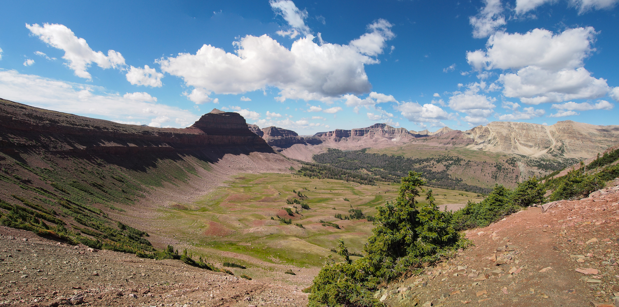
We'll need to get started relatively early, because I'd like to get to the Red Castle basin area by evening, with plenty of time to set up the tent and explore a bit before hitting the hay.  We'll take the Bald Mountain trail up over the summit of gentle Bald Mountain (no relation to the 
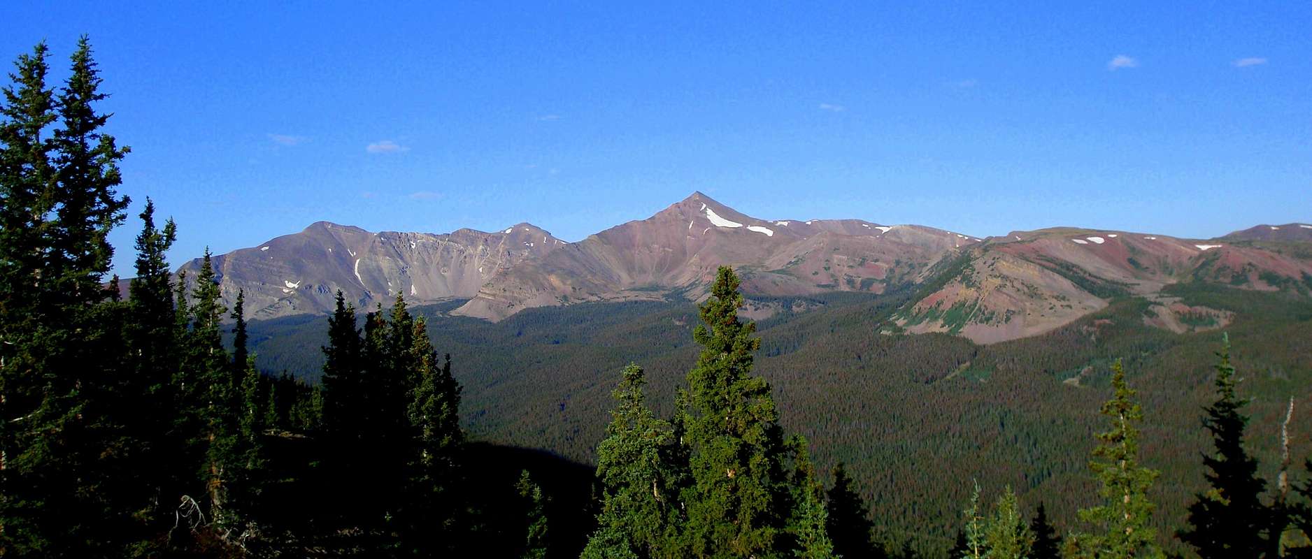
other Bald Mountain we did on Monday) which offers a connecting trail from East Fork Blacks Fork to the East Fork Smiths Fork trail (which trailheads out of China Meadows normally.)  Shortly after joining it, we'll take the Red Castle junction to the west rather than take the East Fork Smiths Fork up to the Smiths Fork Pass.  Lower Red Castle Lake has a very scenic appeal to it, and no doubt we'll stop there and take some pictures and stuff, but I'd probably like to push on a little farther and camp at Red Castle or even Upper Red Castle Lakes... if there are any trees still that high (indications are that there are not, but I've heard other guys talking about camping beyond the Lower lake, so I know if can be done.)
Red Castle from near Lower Red Castle Lake
This will be a fairly long day of walking, but very scenic; we'll have to log a good 10 miles probably.  Maybe a bit more.  Here's one account of what we'll be doing:  http://www.utahtrails.com/Backcountry%20pages/RedCastle.html

Here's another, although ignore the second half of his trip report after the night in the Red Castle area; I'm doing something different (and more involved) to get back:  http://backcountrypost.com/threads/red-castle-little-east-fork-blacks-fork-uintas.823/

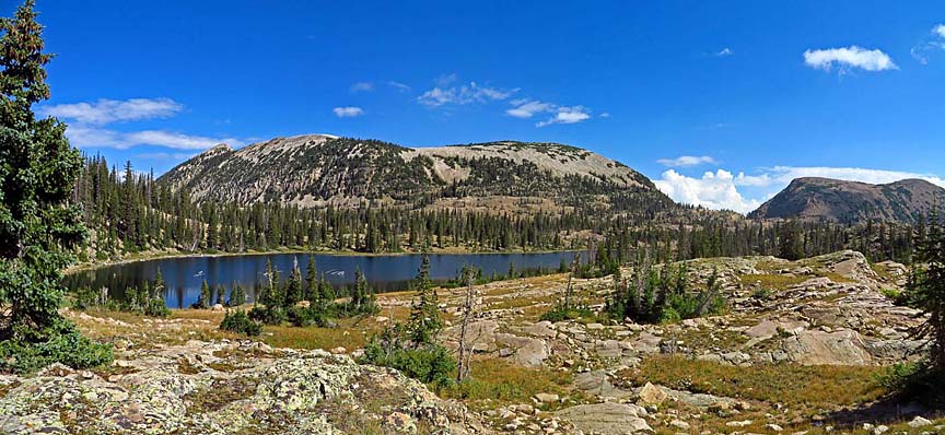
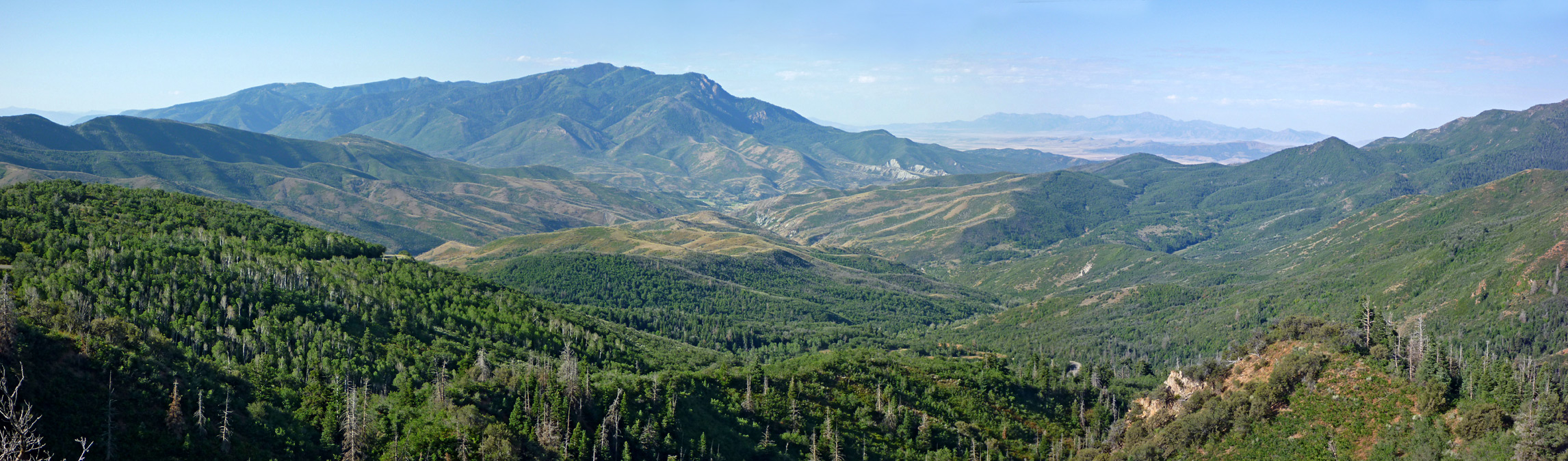
Wednesday: Taking the un-mapped trail over the pass mentioned in both of those links above, actually, I'll join the Highline Trail early the next morning and head west, past Lambert Meadows and around Lovenia.  My initial thought is that I'd go over Red Knob Pass and camp somewhere between there and Dead Horse Pass.  I don't actually intend to go over Dead Horse Pass, but I'd love to climb to the top of it and have a good look into the Rock Creek Basin from the east, at least, before coming back down.  Exactly where we camp, though, is dependent on how fast we're going and how we feel, and what the weather's like (always a potential iffy point in the mountains.)  If it's too early when we reach the destination, I may turn off the Highline Trail and go into the Lovenia Basin and set up camp there.  Otherwise, I'll get there early the next morning.  Might bag a peak or two.  "Red Knob Pass Peak" will certainly be conveniently close.
Red Knob Pass looking towards Dead Horse Pass
Thursday:  Here, I'm thinking of hiking fairly little and exploring a bit more.  If I didn't already make it to Lovenia Basin on Wednesday, that will be the first priority; getting there and setting up camp.  From here, I'd like to explore the area.  Possibly hike up "Wasatch Benchmark" and even "NW Wasatch", check out the cirque area between the Wasatches and Tokewanna, etc.  If there's still time and we have energy, we can even explore Little East Fork canyon a bit.  But I don't want to promise that.  Plan is we head back to the basecamp for the night.

Friday: From here, we head back to the trailhead.  It's a nice walk, but shouldn't take more than half a day, probably.  Thursday and Friday will resemble this guy's trip quite a bit, except I have no intention of trying to summit Lovenia or East Lovenia.

There's probably still time to do something else on Friday afternoon and evening; get started on another hike, or whatever.  But this depends on what my brother needs to do at this point.  If he needs to head back home on Saturday, then we'll just drive to a convenient place to camp and be done for the day, other than hanging out at the campground and exploring a bit.  Heck, maybe this is a good time to head back to the Mirror Lake Highway again.  If he leaves on Saturday, I can explore Mount Watson and Notch Mountain on Saturday, spending Friday and Saturday night at the same campground.  And if I want to save $20, I can go a mile or two up the trail from the developed campgrounds and practice "dispersed camping" instead.

The nice thing, of course, if I'm overestimating the amount of distance we can travel, then this has a fair bit of padding built in.  We can stop and take it easy if we like, or we can hoof it more if we need to to make our miles.  I'm assuming that the situation will resemble the former more than the latter, but you never know.  We might find it harder to hike in the mountains than we think, given the elevation and the fact that we don't do this as regularly as we'd like.

Beyond:  Here's, of course, where I need to decide what to do, since I will have done the one part of the trip that I most want to.  I could, for instance, do the western Uintas exploration, as described above (Mount Watson, Notch Mountain, maybe even Haystack Mountain.)  If I do this, I'd stay Friday and Saturday night in this area, and then Sunday morning, I'd go do something else.  In fact, if that's what I do, I'd like to head to Timpanogos in the nearby Wasatch Mountains.  Start the hike on Sunday sometime and get to Emerald Lake.  Set up camp there, and spend the night on Timp.  Hit the summit on Monday morning before heading back to Vernal via the southern route (so I can see different scenery, at least.)

On the other hand, I could break camp on Saturday morning at head back into the High Uintas Wilderness.  I have two more nights and two and a half, almost three days to kill; I could go back to Naturalist Basin and explore it better, I could go over Rocky Sea Pass and see Rock Creek Basin from the west side, or I could even come down into Allsop Basin, Amethyst Basin or Middle Basin.  If I have to take Samuel somewhere away from the Uintas, maybe I should just go see something else: Goblin Valley State Park, the La Sal Scenic Loop, the Mount Nebo Scenic Byway, etc.  Lots of options.  It also depends, I suppose, on whether or not I'm tired of hiking and would rather do some car-sight-seeing with limited walking (and no backpack), or if I'm ready for another two-night three-day or hiking after just getting off of a three-night four day trip.
Salt Creek overlook on Nebo Loop Scenic Byway
Either way, by Monday night, I need to be back in Vernal, showering, changing and otherwise getting "finished up."  And I want to have dinner at Cafe Rio, because they have really good Mexican food (my favorite variety of "ethnic" food.  Unless barbecue brisket counts as "ethnic Texan" food.)

Tuesday and Wednesday, I'm driving back home.  This shouldn't be difficult, but I don't really have time to do anything exciting.  I lose an hour each day.  The idea is to get to Omaha on Tuesday, so I can have a somewhat shorter day on Wednesday.  Thursday bright and early (or at least some time in the morning) I have to be back at work, so I don't want to arrive too late on Wednesday back at home.  Plus, after a week and a half, it'll be good to see the family again, show them my pictures and talk them through my trip.

Friday, March 6, 2015

Scaling back

Well, I realized that I had an extra day planned in my itinerary; that is, I'm going to have to cut it a day short.  Add to that some potential other constraints; i.e., meeting my brother's scheduling needs, and the fact that my itinerary was probably a bit too packed/ambitious to begin with, I'm thinking I may need to cut it back a little bit.  I'm considering making the following change:

  • Start on Monday at Bald Mountain.  Because my brother and I will be coming from different directions, this makes the most sense, and I can meet him somewhere in the area on Monday.  Because I can't there too early, this is a good one to set up a base-camp, stay there maybe two nights and do some day hiking.  I'd like to hike to the summit of Bald Mountain (there's actually a trail that goes to the top) but I'd like to do a loop around Notch Mountain and Mount Watson, and maybe hit an off-trail summit or two there two.
  • If we go into the Wilderness area itself on Wednesday morning, that gives us probably four days to explore in an out-and-back fashion.  This would be the Naturalist Basin and Rock Creek Basin exploration, with the potential to get my brother back on the road sometime on Saturday.  Three days, I guess, if he wants to hit the road Saturday morning instead of Saturday evening.  If that's the case, I'd probably cut Naturalist, since I was there last year, and just see Rock Creek instead, maybe in more detail.
  • I don't need to be done hiking until Monday evening, though, which gives me two to three more days, depending on when Samuel packs out.  Depending on how much time I have, I'm considering either the Red Castle area, or bailing on the Uintas entirely and doing Timpanogos.  My only concern with the the latter in particular is that there may be 4th of July weekenders all over the mountain, making for a crowded experience.  I'm also considering bailing on the Uintas to go see something else entirely, like the La Sal or Henry Mountains, or Goblin Valley State Park and the Wild Horse and Bell slot canyons, or something.  The first of the options is probably the most ambitious, the middle option has potential crowd issues (although on Sunday/Monday after the holiday, maybe I'm overestimating how bad it'll be) and the last of the options is more wide open, but I'll have to merely (and probably unsatisfyingly) sample some of those locations rather than really see them like I'd like to.  Those also will require a fair bit of driving to reach.  And they may have crowd issues too, for all I know.

Tuesday, March 3, 2015

Uintas trips

While there's really no substitute for the Trails Illustrated map of the High Uintas Wilderness (except maybe the quads by the USGS, but I prefer the NatGeo one for a lot of reasons) here's a simplified map that at least shows the roads and trailheads which is useful for high level planning.  It's totally inadequate for detailed level planning or for use in the field, but that's not its purpose, and that's OK.

http://www.fs.usda.gov/Internet/FSE_DOCUMENTS/stelprdb5097865.pdf

Since I have come up with the concept of smaller backpacking trips; heading into the area, spending a few days seeing some sights that are within relatively easy reach of a single trailhead, then coming back, driving to a new trailhead and doing it again, I've decided to itinerary-ize some possible trips in the High Uintas.  This will keep me busy for years!  To say nothing of the Wasatch, the Henrys or the La Sals.  To say nothing of states outside of Utah!  None of these have been done by me to my satisfaction, so they are all potentially still on the table.  The ones that I have penciled in for doing this coming summer (in just about four months now!) are in bold.

  • From Bald Mountain campsite: 
    • Bald Mountain summit, then hike to Notch Mountain.  Potentially to loop around back to the campsite; probably a long single day.
  • From Hell Hole TH (my own name; it appears to be unlabeled):
    • Hell Hole basin and Hell Hole Lake.  Climb A-1 and/or Kletting Peaks (did this last year, but didn't get the peaks.)
  • From Christmas Meadows TH:
    • Middle Basin (potential summits include Hayden, North Hayden, Agassiz, Spread Eagle, Ostler.  Potential to cross ridge into Naturalist Basin, although there's no good way back to the car if I do this.)
    • Amethyst Basin (potential summits include Ostler, Lamotte)
  • From East Fork Bear River TH:
    • Allsop Basin
    • Priord Basin (the can be combined into a loop via the pass between Yard Peak and North Yard Peak.  Potential peaks to summit or at least clamber on include Yard Peak, Priord Peak, Cathedral Peak, and Mount Beulah.  Maybe Lamotte from the east.)
  • From Highline TH:
    • Naturalist Basin (potential peaks include Agassiz and Spread Eagle Peaks) (did this last year too, but didn't see everything I wanted to, and made no attempts on any peak or even on the ridge between the two peaks.)
    • Rock Creek Basin (potential peaks abound.  This could also be continued further on, although that starts to defeat the purpose of moving the car from trailhead to trailhead if I go beyond Rock Creek.  That said; I'd like to get up to Dead Horse pass and at least look beyond.
    • Four Lakes Basin
  • From Grandview TH:
    • Grandaddy Basin, including East and West Grandaddy Mtns
  • From Rock Creek TH:
    • Grandaddy Basin
    • Rock Creek Basin
    • Ottoson Basin
    • Squaw Basin
    • Four Lakes Basin
    • Brown Duck Basin (all of these can also be reached from the Highline TH.  Most of these destinations are fairly remote and it's a longish hike to get there from either trailhead.)
  • From East Fork Blacks Fork TH:
    • Wasatch/Tokewanna area - can be looped with some of the other destinations.
    • Lovenia/Red Knob Pass
    • Squaw Pass
    • Red Castle Basin
  • From China Meadows TH:
    • Red Castle Basin
    • Henry's Fork Basin
  • From Henry's Fork TH:
    • Henry's Fork Basin (including King's Peak, and various other high 13ers)
    • Painter Basin
  • From Uintah Canyon TH:
    • Krebs Basin =» Atwood Basin
  • From Hoop Lake TH:
    • The Burro Peaks area
  • From Hacking No. 1 Lake
    • Marsh Peak, Leidy Peak and Untermann Mtns.
Obviously, some of those trip destinations overlap.  If I go into Rock Creek Basin from the Highline Trail coming from directly west, I'll certainly feel less motivated to get to the same destination from the Rock Creek Trailhead far to the south.  If I take East Fork Blacks Fork TH to the Red Castle area, will I go back from China Meadows?  Most likely not.  In fact, most likely I don't have any reason at all to use the China Meadows TH, because every destination I can reach from there, I can do better coming from either East Fork Blacks Fork or Henry's Fork.

That said; I dunno.  I might spend more time in the Uintas than even I imagine right now.  I'd really like to see more of Montana, Idaho, Wyoming and Colorado than I would going back over and over to the Uintas, but as I've said many times; the Uintas have a lot of convenient features for me, and I do really like them.  They are, in a way, my mountain range.

I've attached some images that I grabbed from Summit Post, for a change of pace, these are of the Grandaddy area.

Agassiz as seen from the Grandaddy Basin

Cliffs of East Grandaddy Mtn

Climbing East Grandaddy

Grandaddy Lake from the Top

Murdoch and Bald Mountain from the Grandaddy area (I saw both from very different angles on the Highline route.)

West Grandaddy

Monday, March 2, 2015

Profile of the Uintas

My favorite mountain range, or at least the one where I'm certainly spending most of my energy in terms of planning trips and whatnot, is the Uinta range of northern Utah.  Part of the reason for this is relative convenience; I have a sister-in-law that lives with her husband and my nieces in Vernal, a town in the southern foothills of the mountains near the Colorado border.  Because I can get to their place in two days, that means I can take relatively nice and easy driving days, and only spend one night in a hotel on the way.  I need a couple of hours to get from Vernal to the trailheads I'm likely to use, but it's still a convenient bridge-head into the area.

The Uintas as an unusual range, as they are the highest and probably the longest east-west range in the contiguous lower 48 states--and only the Brooks Range in northern Alaska beats them in North America overall.  Brought up via the Laramide orogeny many millions of years ago, the core of the Uintas is extremely old Precambrian quartz arenite, but the orogeny also raised a number of other types of rocks, most of which make up the flanks and eastern end of the range, while the exposed core makes up the central and eastern portion of the range; this core is an unusual reddish color in many lights, and can vary from brown, tan, gray, pink or maroon, depending on the rock and the light conditions.  The rock is also fragmented and "rotten"; it makes poor technical climbing.  In many ways, in nature, this rock is very similar to the rock that makes up the Maroon Bells and much of the Elk Mountains in Colorado, and the Uintas have a similar look to them.

The Uinas are geologically dead; the only thing happening to them nowadays is erosion, but that's a very slow process, so they'll be with us for millions of years more.  They were highly glaciated during the peak of the Ice Age, but they have been free from glaciers for, at least, all of the recorded history of the area.  The glaciers certainly left unmistakable marks, however; the character of the Uintas is that of a number of high ridges, with ragged tops broken up into a number of related peaks.  Separating these ridges are wide basins where valley glaciers once sat.  This means that the typical Uinta peak has a very predictable profile; a rather squat pyramid, sometimes with some carved cliff faces, but often with just big talus slops leading most of the way up to pointed peaks.

The Uintas are the highest peaks in Utah, and only a few ranges north of them have peaks that are higher (although the Wind Rivers in Wyoming manage handily, and the highest of the Tetons is higher than the highest of the Uintas.)  Going with the guide of having 200+ feet of prominence, the Uintas have 19 peaks over 13,000, with the highest, King's Peak at 13,528.  Even with the stricter 300+ feet of prominence, there are over 17.  Curiously, only about half of these peaks have official names.  The Uintas are an extremely remote range, with very little in the way of settlement, very little in the way of development and very little in the way of roads or visitation, really.  A handful of areas get relatively high visitation (although compared to tourist magnets like Yellowstone or Yosemite, it's still a fraction of that) but many of the remote, unnamed peaks only see a handful of summits a year, if that.  It's not hard to find solitude in the Uintas, once you get off the beaten track (basically, anything right along the Mirror Lake Highway, or right along the Highline Trail west of Rocky Sea Pass, or anything right along the Flaming Gorge area.)

Uintas on Google Earth
Summit Post divides the Uintas into four areas, going from west to east, these are:

  • The Western Uintas and Lakes Roadless Area.  Essentially the area west of Mirror Lake Highway all the way to the edge of the range in the small town of Kamas.  This section of the mountains is mostly but not completely public land, and the peaks are relatively low and often rounded and covered in trees, although they start taking on a much more alpine character as you get closer to the Mirror Lake Highway.  Personally, I believe that the presence of the Mirror Lake Highway and the official wilderness boundaries are somewhat arbitrary; this area truly belongs with the High Uintas as the "core"of the range; the last two sections are eastern portions of the mountains that both have very different character from each other and from the first two areas.
  • Shortly to the east of the Mirror Lake Highway, you come to the High Uintas Wilderness Area.  This is the true core of the mountains.  All of the tallest peaks are located here, as well as most of the most scenic and beautiful ones.  Supposedly, this part of the range has the most contiguous (along with the San Juans of Colorado) alpine tundra above treeline.  I can believe it; there's a lot here.  The most rugged parts are in the west, although the Henry's Fork area, where the two tallest peaks in Utah are located (as well as several other 13ers) is also very rugged.  With the exception of the path through Henry's Fork Basin to King's Peak, which has attracted a lot of notice because it's a state highpoint, and a few other spots to the west of Rocky Sea Pass, the area is relatively little visited.  It's all very remote, and approaches to any of the areas are long.  It's very hard to find very many in and out day trips in the area, but longer backpacking jaunts abound.
  • To the east of the Wilderness area are the remote High Bollies or Eastern Uintas.  This area is bisected by US Highway 191 which is the route you need to follow to get from Vernal to I-80.  Much of this is public land as well; belonging to the Ashley National Forest and the Flaming Gorge National Recreation Area.  The peaks here tend to be remote, seldom visited, yet not hard to reach for those who care to.  They are rounded and forested, although many rise above treeline.  In the map above. this is the part of the longer, straight line that shows as forested.  The entire length of these three combined portions of the Uintas is about 105 miles.
  • Although not always considered as such, Summit Post makes a good case that since the Dinosaur National Monument area was formed by the same mountain building events and faults, it should be considered part of the mountain range as well.  This eastern rump end is mostly the part shown above east of the kink in the red line.  The character of these mountains is quite different.  Because they are lower, they still retain many of the capstone formations that have been completely weathered away in the core areas of the Uintas, including many formations well known in the Colorado Plateau region; the Kapairowitz, the Mancos Shale, the Morrison formation, Cedar Mountain, etc.  Interestingly, as you cross the Uintas from Wyoming to Vernal on US-191, there are a number of signs all along the road telling you what formations you are seeing outside your car window, and what kinds of fossils you can find therein.  While I doubt most tourists passing through care quite as much as I do about geology, I still find this very interesting.  The mountains themselves in this rump end of the Uintas take on a distinctly desert rather than alpine character.  There are also a number of remote and beautiful slot canyons in this area.  Adding this leg, the eastern part after the kink in the red line above, increases the length of the range to right around 150 miles.
The Uintas have a wide array of wildlife; mountain goats, elk, moose, various other deer.  Grizzlies have been extinct in the region since pioneer times, but there are (allegedly) a few black bears in the region.  Nobody I know of uses bear cannisters, but it is recommended that you hang your food (unless, of course, you're above treeline.)  Last time I was there, I normally did, but the first night, when I hadn't yet acclimated to the altitude and I had a pounding migraine and it was raining on me to boot, I didn't bother with it.  The wildlife you're much more likely to encounter are squirrels, chipmunks and--and this may surprise some--large herds of sheep and cows.  When the High Uintas Wilderness Area was formed, some of the meadows were already being used by ranchers as grazing pasture, and as part of the deal when the Wilderness Area was designated, they retained grandfathered in rights to keep their cows and sheep in the area.

Like much of the Rockies, afternoon rain isn't unusual, although the surrounding climate is dry enough that it's rarely prolonged or really hard rain.  Thunder and lightning can accompany these cloudbursts, so it's wise to plan exposure in peaks and high ridges for either earlier in the day, or later in the afternoon, and keeping exit plans open in case bad weather rolls in.  Last August, I had very little in terms of clear skies; I never got a good starry night, for instance.  It's high; even the lower basin floors are often above 9,000 or even 10,000 feet.  Many peaks are over 11,000 and 12,000 and--as noted above--quite a few top 13,000.  It rarely gets really warm, even in August.  I kept a fleece with me at all times, and if I stopped walking, I usually needed to put it on fairly quickly, or start feeling chilled.  Most of the trails are stock friendly, and there are nearly as many horse-parties in the range as there are hikers.  This means that the trails are graded fairly evenly, and stick to the basin floors, often in the trees.  It's hard to get too lost in the Uintas, however, because of the basin and ridge topography that they have.  If you want to get above the trees and ramble off-trail, you won't get lost.  Very few of the peaks and ridges have maintained trails on them, but lots of folks cross passes and ridges that are untrailed, and do it without too much problems.  The peaks of the Uintas are usually considered walk-ups; i.e., they are not technically challenging, and as long as you can handle the elevation gain and don't mind picking your way through loose scree for much of the route, they can be done by even the uninitiated.  It's recommended (by me, at least) to have shoes with some kind of ankle support, however.  Boulder fields and loose scree isn't the funnest to walk on otherwise, and keep in mind that most hiking injuries are to ankles and feet.  A rolled, twisted or even broken ankle in the Uintas back-country will really ruin your day.

One of the things that I love about the Uintas, however, is that they feel relatively safe.  Reasonably safe terrain, especially if you mostly stick to trails, lack of much in the way of really dangerous wildlife, phenomenal natural beauty and lots of opportunity for solitude, as well as relatively easy access, make the Uintas one of my favorite mountain ranges to visit.  They're also really quite large, meaning that there is almost always opportunity for even the experienced to find something new to explore; it would take a lifetime to really get to know these mountains as well as I'd like to.  I've already used up half of mine, and I've got other things to see besides just these mountains, of course, so I'll never get to know them as well as I'd like, but I do feel a certain sense of belonging here; almost as if these are my mountains.

Mount Agassiz from the north in Middle Basin

Approaching Allsop Basin

An above tree-line cairn to mark the Highline Trail.

Christmas Meadows, with Ostler and Spread-Eagle Peaks from the north

Red Castle

Gunsight Pass and "West Gunsight Peak" also known as "Dome Peak."

Ostler Peak, showing, again, the very typical Uinta Mountain profile

Old-fashioned hiking boots

While I've now migrated into wanting synthetic, lightweight hiking shoes rather than traditional leather boots, I have to admit I still really like the look of hiking boots.  I'd wear them around town, even if I'm less interested in wearing them on long hiking trips anymore.  And there are some, especially if I'm going to be seeing lots of rain or snow (or the possibility of it) along with off-trail rambling, that I wouldn't mind wearing, usually highly engineered ones that are lightweight.

The Perfekt series by Meindl, especially the light hikers or vented light hikers, may be the best bet.  I also like some by Danner; the Extroverts have the look of a traditional boot while really being a synthetic ankle-supporting hiking shoe, but the Nobos and the Mt. Defiance, and the 452s are all Danner boots that I wouldn't mind owning, and in which I'd probably hike.

I always tell people that I don't get hiking clothes to be Backcountry Chic, but let's face it; everyone likes to wear stuff that they like the look of, and most people like to broadcast their tastes and preferences via their look at times.  I love hiking boots; I've worn them off and on as simply shoes ever since I was in high school many years ago.  I'd do it again.

Vegan shoes

I've said before; I "like" Backpacker Magazine on Facebook, which means that my feed has articles highlighted by the magazine; usually several a day.  Often these generate discussion in Facebook itself.

One that popped up recently was an article highlighting vegan shoes.

Now, I've said many times, although maybe not here exactly, that I struggle a bit with my perception of "hiker culture."  Hiker culture, at least as presented by backpacker authors and journalists, seems to skew highly towards the PNW granola set; cultural (and economic, for that matter) Marxists and hippies.  I have little patience with this vibe.  A friend of mine, who I bumped into at REI once when he was buying a replacement mouthpiece for his Camelback bladder, said that REI was the place where outdoor-loving hippies shop, while Cabela's is where outdoor-loving rednecks shop.  Although REI seems to focus much more than Cabela's on the types of activities that I enjoy outdoors (I'm not a hunter or fisherman, but I love hiking and backpacking), I still feel more at home at Cabela's than I do at REI for precisely this reason: I dislike this hippy nonsense.  Plus, Cabela's has recently made an effort to deliberately reach out to their customer base that already enjoys backpacking and other outdoor activities besides hunting and fishing, with their XPG line, and others.

Vegan shoes is exactly the type of hippy nonsense that I'm talking about.  I've never yet met a Vegan who wasn't a completely pretentious, smug, self-righteous douche-bag.  I think the movement inherently attracts exactly that type; it serves no purpose other than to be a positional good; that is, it's entire purpose is to give to its consumer (i.e., the vegan himself) a sense of self-righteousness.  This includes, for the record, many of those who responded in the Facebook comments to the article above.

I was gratified, however, to note that the presence of pro-Vegan, or even sympathetic, comments were much scarcer than I expected.  A lot of people made jokes about eating your shoes, a lot of people made mention of the fact that they've never met a Vegan who was likable and not militaristic preachy and obnoxious.  A number of other people expressed some slight dismay, or at least a warning, that they come to Backpacker for articles on backpacking, and have no interest in preachy hippy nonsense.

Of course, where I've been backpacking lately, in Utah, the climate tends to be less sympathetic to hippiness in general.  But still, I was encouraged by the trends.  Most of the pro-Vegan comments really only came from a very small set of individuals who responded a lot, making their frequency appear greater than it really was.  I think that maybe I have more in common with my fellow backpackers than I thought.  Maybe it's not a hobby that's as rife with smug granolas as I thought.

Although I will admit that the smug granolas tend to dominate a lot of the discussion and appear to be more prevalent than I suspect that they actually are.  Such is the way of things, though, in other hobbies of mine as well.


Sprite Granola Cola - Grimace from Steve Doppelt on Vimeo.