Well, we spent some time looking over my scheduled vacation for 2017. Because of my youngest son's Type I diabetes, I've had to commit more days to following him around while he's doing things like out of town field trips, Scout camp, etc., which has reduced my available vacation considerably. While I earlier had thought that I had some days to spare, it looks like I'll have to keep my hike down to a good, solid week alone. If I use the weekends on either side of the week to travel out west, that gives me exactly 5 days. The only way I could potentially resurrect a slightly longer hike is to use the Labor Day Weekend as the final bookend, but even then, that only buys me one additional day. So, I had to get my very ambitious 7-day southern Wind River hike reduced by two days. This meant 1) cutting out either the Bonneville Basin and Pronghorn Lake spur, the Baptiste Lake spur, or the Deep Lake and Temple area spur (I've elected the first), 2) spend a little bit less time just exploring, i.e., no two-day stop in the Cirque of the Towers area, and 3) do a little bit of backtracking to maximize travel time rather than maximize spending as many trail miles as possible on a different trail.
Here's how it turns out:
Day 0 (Sunday): After spending the night in mid-Nebraska, I head out west into Wyoming again. At Rock Springs, instead of turning south for Vernal like I did the last two backpacking trips, I head north towards Pinedale. Curiously, the distance is almost exactly the same, which means that I might yet have some time to go see Scott's Bluff one more time, or better yet, do some exploring of the Oregon Buttes or some other features of the Great Divide Basin area, since I've now seen Scott's Bluff twice. I don't want to take too long, though, as my goal would be to actually spend Night 0 at the Trailhead, which is Big Sandy campground. If I go try to go see Oregon Buttes or something like that, it actually will take me off the interstate earlier, at Rawlins. And I don't quite go all the way to Pinedale before turning off to get to the Big Sandy campground.
Day 1 (Monday): A relatively big 11½ mile day, but since I'm sleeping literally at the TH, I can be up really early and take my time. Although it does gain some elevation, it's mostly very gradual. I get, at the end of the day, to Mae's Lake, the last area along the way to Pyramid Lake where there are trees near a lake, making it an ideal camping area.
Day 2 (Tuesday): Leaving the campsite without breaking camp yet, I can continue on to Pyramid Lake and into the East Fork valley to have a look around and explore. I mapped the little blue spur all the way to the high lake at the cirque walls, but chances are I won't actually walk that far before turning back around. I plan to be back at camp around lunchtime to eat a bit, break camp, and then go over Hailey Pass with my gear. This part of the day is just shy of 4 miles, and gets me to the Baptiste Lake area, where I want to have some time to look around before the sun sets, and take pictures of the huge rock wall of Mount Hooker.
Day 3 (Wednesday): This is mostly a day of backtracking; a concession I had to make due to my shortened itinerary. I could go around and see new trails, new valleys, new peaks, etc.—but it would add miles and therefore time. This is an 8½ mile day, so long, but not terribly so, and other than gaining 900 or so feet to go over Hailey Pass again, it's actually mostly downhill. Near the end of the hiking day, I turn and head towards Shadow Lake where I set up camp. If I'm making better time than I think I'm likely to be making, and I still have some energy and some more daylight, I could keep going up and over Texas Pass at the end of the day and come in to camp in the Cirque of the Towers area; a highly desirable outcome... but I'm not planning on it, necessarily. It would add more than 2 and probably closer to 3 miles to my day. But maybe it's worth it to push on Wednesday so I can have a better Thursday, with some time to explore the Cirque area before having to move again. I did add the Lonesome Lake area as an alternate Night 3, at least.
Day 4 (Thursday): At almost 8 miles, this is a decent sized day with two big passes; although if I have pushed it on Wednesday, it's down to only about 5 miles and one pass. Either way, it's where I get to see the Cirque of the Towers, either mid morning after crossing Texas Pass, or first thing in the morning, where I can walk around it before even breaking camp. Then I go back over Jackass Pass and head towards the car. Rather than going all the way, though, I turn east at Big Sandy Lake and make camp at Clear Lake, with views of the Temple area. Cirque of the Towers exploration will probably make this day longer than it appears to be just based on miles that need to be crossed, but if I somehow have time, I'd like to climb just a bit further up the trail after setting up camp to see Deep Lake too. Although according to the map, camping at Deep Lake looks iffy, I've seen plenty of pictures of people who have done it. Maybe I'll just go all the way there for the night. It's not even another full mile after Clear Lake, and the views are certainly better.
Day 5 (Friday): Continue the loop, either from Clear Lake or Deep Lake, around the little x10,980 massif without a name, and back to Big Sandy Lake. From there, get back to the car. It's just shy of 10 miles today, although really only 9 if I make it closer to Deep Lake the night before. This should give me time to get back to the car with some time to spare, so I can drive out of the mountains, check into a hotel and take a shower before heading home. If that ends up not flying, well, I can always take a quick dip in a lake somewhere and then just change into some clean clothes at the car for the next day. Saturday and Sunday are, again, driving back home days.
What does this route miss that my bigger route had? I lost the area beyond the East Fork Basin. That's a real shame. I'll want to come back for that some day. I also don't get to see Grave Lake, Ranger Park, Valentine Lake, Payson Peak, Lizard Head Peak, and the whole eastern approach into Cirque of the Towers. I'm worried about feeling rushed at the Cirque, which really should be the headline destination of the whole trip. If I pushed it more, I could maybe get a little bit of that back, but I'm wary of having too many too big days. I'm not as young or spry as I used to be, and I live at a lot lower elevation; closer to sea level. Having hiking days that are less than 10 mile minimums is a good thing, and if I get more miles out of some of the days where I have the option to do that, that's a surprise and delight bonus rather than something that I have to do.
Total Backpacking mileage: 41.84
Total Potential mapped Dayhiking mileage: 7.82
Total total: 49.66
Monday, November 21, 2016
Wednesday, November 16, 2016
And why not pants?
I recently went on a search for some good hiking blogs, and found some poll that was conducted of hiking blogs and it had picked a Top 10 list (with an additional half dozen or so runners-up.) I looked at them, and hated the formatting of almost all of them. In addition, most of them were literally crying about the election, because in the catechism of their bizarre, nihilistic Green cult beliefs, the election of a Republican is a sign of the End Times.
Sigh. It was a nice try, I suppose, to find some good hiking discussion. The best one of the ones I saw was pretty nifty, but it was specifically relegated to southern California hiking locations. If I could find a similar blogs for various spots in the Rockies, I'd be very happy. But I didn't; so since I'm lacking in good hiking sites to read, I guess I'll keep writing about it. I don't have anything in particular to write about right now, so let me continue, I suppose, my series with regards to gear that I'd like to get, starting with more clothes. My last post was on boots. I'd also like a bunch of new hiking pants, and as with the boots, I'd like to wear them day to day even when not hiking as part of a "wilderness chic" look. Which are some of the ones that I'd really like to have?
Cabela's XPG Trekker Pants: This is my first pick. I'd love all four colors. For the last several months, supply has been limited in my size. They're sold out of most colors in my size for the season, but they should be back in action in a few months. Grr...
Cabela's Great Trail Pants: Although I'm not necessary a big fan of zip-off pants, and the zip-off feature isn't one that I'd use very often (if at all) these are still pretty darn nice looking pants, and they do have all of the other technical features that I'd want (with one exception: insect defense.)
Cabela's Grand Mesa Trail Pants: Cabela's, curiously, has a lot of pants that I wouldn't ever want to actually take into the backwoods, because they're made of thick, jean-material like cotton or canvas. These are some good cargoes that I could use, however.
Cabela's Guidewear Insect Defense System Pants: The last of the Cabela's pants that I'd want. Although I still tend to shy away from the "trendy" brands like Columbia, The North Face, Patagonia, etc. whenever possible, I do have to admit that Cabela's doesn't meet my needs quite as well as I'd like in regards to pants to hike in. Sigh. So, I have to dig a little deeper for this category.
Luke Bryan's 32 Bridge Huntin' Fishin' and Lovin' Every Day Performance Pants: OK, I'll probably not seriously consider these. I'm not really a country music fan, to be honest, and even if I was, it's even more dubious that I'd be a Luke Bryan fan. And the name is so cheesy. But, performance pants are performance pants, right? And I do like to patronize Cabela's whenever possible, rather than hippy places like REI. In this case, I think going to REI is probably for the best, though—I'm iffy on these pants.
prAna Stretch Zion Pants: OK, so the roll up and snap your pants in place is pretty gay unless you're walking barefoot on the beach or something, but these otherwise look like decent, if over-priced, hiking pants. In fact, they seem rather stylish for a functional article of clothing. If your idea of style was formed when parachute pants were in. Which isn't actually meant to be an insult, because it applies very well to me. Their Brion pants are a bit cheaper (although still overpriced) and have the look of a pair of jeans that are made of a nylon and spandex blend rather than cotton.
REI Classic Sahara Convertible Pants: Sigh. Yeah, convertible pants. These are kind of the classic. Good price, too. I still don't care about the convertible function, but what can you do?
REI Screeline Pants: These are just good pants and reasonably well priced. As much as I find the aggressively hippyish REI to be grating as a corporate entity, I have to admit that they've got the goods when it comes to the kinds of outdoor clothes that I'd really want to wear.
Kühl Renegade Jeans: Are a bit misnamed; there's no cotton in them thar hills. I really like the look of these pants, though, I have to admit. Kühl, which is a horribly pretentious name, since they're from Portland or some place like that, not Europe, also have some grossly over-priced convertible pants. (UPDATE: Turns out that the company is actually based in SLC, UT. And it's probably the Renegade Pants that I want more than the Renegade Jeans; the only difference being the "full" vs. the slightly more tapered "klassic" cut.)
Marmot Arch Rock Pants: Another pair of pants that I could conceivably wear to work in my "business casual" environment are these Marmot Arch Rock Pants. I actually prefer my outdoor pants to have a cut that makes them look different than regular pants; some kind of "utilitarian" vibe; extra pockets, or zippers, or a cuff that opens up so they can be pulled on over shoes, etc. And if Patagonia, The North Face and Columbia are trendy, Marmot is one of those brands (along with Arc'teryx, maybe ExOfficio, Mountain Hardwear, and a few others) that is just over the top trendy among the hiker set, which I find a turn-off. These don't look like bad pants, though, and it's not a bad price. I should confront the possibility that in my anti-snobbishness I've actually developed a kind of reverse snobbishness that's just as ridiculous.
Eddie Bauer First Ascent Guide Pro Pants: A friend of mine, who's also into hiking and other outdoor sports, has some of these and loves them. In fact, I think he loved them so much, he went back and bought more of them. I've actually put them near the top of my list for desired pants, to be honest with you. And they come in several colors, which means I could get 4-5 pairs of them without feeling like I'm just stuffing my collection.
L. L. Bean Cresta Hiking Pants: Growing up, I always thought of L. L. Bean and Eddie Bauer as similar; even comparable. The Cresta Hiking Pants seem to be their best competitor to the Guide Pro pants—and they're cheaper! These also come in several colors, making the idea of stocking up with several not a bad notion.
Railriders Bushwhacker Weatherpants: These have great reviews, but they may be the priciest of the bunch, and I really dislike that style of sizing (just give me regular waist and inseam measurements please!) Still, I can't argue with their reputation.
As with the footwear; what will I end up settling on here? I'm kinda thinking of getting some pairs of the Cresta Hiking Pants, the First Ascent Guide Pro pants, the Kühl Renegade Jeans and the REI Screeline Pants. One of each, first, to see how they fit and how I like them, and then more colors of the ones that I really like. And then maybe a pair or two of the XPG Trekkers.
Ideally, I'd replace my entire casual and business casual wardrobe with pants from this list: Of the Kühl Renegade pants, I'd pick up Carbon, Khaki, Breen and Gun Metal—four pairs (all except the Pirate Blue.) Of the L. L. Bean Cresta Hiking Pants, I'd get another four—Classic Black, Dark Driftwood, Dark Loden and Granite. Of the Eddie Bauer First Ascent Guide Pro Pants, I'd buy another four or five—Aged Brass, Dark Smoke, Saddle, Slate Green and maybe Black. Of the Cabela's XPG Trekker Pants, I'd buy three—Foliage, Timberwolf Grey, and Gunpowder (all of them except Baltic Blue) and I'd buy both Army Cot Green and Burlap of the REI Screeline pants. That's eighteen pairs of pants; close to twice what I wear on a regular basis right now, so that's certainly overdoing it. But... man, I like them all.
Tuesday, November 15, 2016
Obsession with footwear
Seriously; you could be excused for thinking I'm a woman sometimes. I love footwear. A good pair of comfortable hikers is one of my favorite things in the world, and I need to figure out, honestly, how to quit my cubicle day job and find some work where wearing them all of the time is just what I do.
And then, of course, I'd need at least half a dozen pair at a time so I can mix them up and have plenty to go on. Add to that a pair of really good and tall (8"-10") hunting boots, a pair of cowboy boots, and a 6"-8" pair of black duty boots, and I'd be good to go. Heck, I'd even wear those duty boots to church if I thought I could get away with it. I probably can get away with cowboy boots to church, especially if I switch to a slightly more "casual" chino style pants instead of dress slacks.
Anyway, I'm quite happy with the boots that I have now, and I'm honestly not likely to wear them out any time soon, because I don't really wear them as much as I'd like—plus they seem like real keepers that'll be good for a long time anyway. But I'd like to have some spares, and every so often, I like to go through various catalogs and see which ones I'd like to get.
And again; I'm talking actual boots. I wouldn't mind some hiking shoes, or trail runners, or whatever you want to call them too, and honestly I'd probably wear them just as much. But for mid-height (or more) hikers, my top choices would be the following:
Cabela's Men's DPX Hikers: These are the same as the boots that I have, actually. They rebranded them slightly (got rid of the XPG sub-brand) and replaced the GORE-TEX lining with their own Cabela's 4MOST Dry Plus lining, but otherwise, the boots are practically identical. Since I like the ones I have, replacing them with another pair of the same (the colors vary somewhat) seems smart.
Cabela's Men's XPG 2.0 Hikers: On the other hand, these are the XPG 2.0s. A little heavier than mine, but probably not noticeably so. This seems to be because the toe-box has been widened to allow for a more comfortable fit after the feet swell a bit on long hikes.
Cabelas's Instinct Men's Pursuitz Hunting Boots: Are actually exactly the same as the XPG 1.0 Hikers, except with a camo pattern. Actually, the rand around the edge may be bigger. I need to actually look at these in person again, while wearing my older boots. Anyway, all of these options are very similar (if not practically identical in the case of two of them) to my existing boots, except for color and the brand of the water-proof liner. These remain near the top of my list, if nothing else, because they're already the same as a pair of shoes that I own and like. Don't rock the boat if it's working, and all that.
New Balance 703 Country Walking Shoes: Not sure if these are on the way out or not. There used to be two colors, now there's one, and the larger sizes (including what I'd need) don't seem to be in stock. This is often a sign of a shoe that they're just selling their existing inventory of, and then not reordering, either because it's out of production, or they're just not going to carry it anymore. If so; that's a shame. I came very close to picking these instead of the ones I did get. And I think I'd have liked them, too.
Danner 453: I really like the Danner brand; another American icon. The 453s are some that I've tried on in the past and really liked. They are a bit more boot-like rather than hybrid shoe-like, like the Cabela's stuff and New Balance shoes are (by which I guess I mean that they have mostly leather uppers and a more boot-like appearance, whereas the others look like beefy, off-road hi-tops.) Although not listed at Cabela's, this all leather option is the best looking of the bunch, I think.
Danner Radical 452: This is a slightly lighter and slightly less expensive pair of boots. I honestly don't know how much I'd hike in these kind of old-school hiking boots, no matter how well made they are, when hi-top trail runners are so in vogue for rather obvious reasons. But they're nice.
Danner TrailTrek: I like these too. Beautiful looking boot. The Danners are a bit on the pricey side, and they're a bit on the heavy side, and they're a bit on the traditional boot side. Sigh. I wish the Extroverts were still in production.
Under Armour Speedfit Hikers: I find these an interesting boot, too—with an almost combat boot appearance, but with very lightweight, hi-top tennis shoe like construction, they don't have a "waterproof" lining, but they do have a water resistant finish. And they sell for a good price, and have very high review scores.
Meindl Perfekt 7" Hikers: Although they're too heavy and too traditional (and too expensive) to ever be something that I'd favor for much actual hiking, you can't deny the fashion statement that traditional all-leather boots make, and the Meindl ones are supposed to be about the best of the best. The Perfekt Hikers are probably the best hoice, although see below...
Meindl Perfekt Light Hikers: The Perfekt Light Hikers (or even the vented ones with mesh panels) are a good alternative. Missing a toe guard or any kind of rand to protect the leather, I think I prefer the former. And "light" here is relative; they're still way over 3 lbs. a pair (my boots are listed as under 2 lbs, although the default listing is for size 9s, I think. I wear size 12, so I probably go over the 2 lbs. mark.)
Meindl Air Revolution Backpacking Boots: This is a beautiful pair of tall, traditional, leather hiking boots. I'm not much of a fashion maven, but I really love the concept of "wilderness chic" and you're only partly there without a traditional pair of hiking boots. Hiking boots and work boots are also nearly indistinguishable in many ways; both are designed to give your feet support and comfort when you're on them all day, but the latter have (sometimes) safety toes and their soles are designed for no slip on wet or oily surface, not for off-road trekking. And who doesn't like the concept of dressing like you're ready to work? Lazy scum, that's who.
Meindl Uninsulated Ultralight Hunting Boots: This is a very, very classic look; old fashioned combat boots in brown leather and made to be as lightweight as boots this tall can possibly be. Love 'em. The Danner Pronghorns are very similar, but I suspect that these are better made.
Cabela's Silent Stalker Sneaker Hunting Boots: Are even lighter, and therefore probably more comfortable to hike in. I like how in the description they're called both "rugged and sensitive." What is this, their Match.com profile?
Cabela's Outfitter Series Hunting Boots: Another very classic look. I don't know how many such "classic" brown leather combat boots I would ever need, but I also don't know which one I'd most want to actually have. I like the price on this one compared to the Meindl boots, which aren't even full leather like these are.
Under Armour All-Leather Wall-Hanger Hunting Boots: I'm actually intrigued by Under Armour. It seems a bit like a "boutique" brand for weekend warriors who are more worried about fashion than anything else (I used to laugh at the gym seeing people in Under Armor and Nike Pro Combat workout clothes while I wore C9, Old Navy or some other brand that was identical, but which cost half as much) but their boots (at least the ones sold at Cabela's) are a good price and have good reviews. I do kind of dislike the prominent oddly colored logo, though.
Meindl Western Slope Hunting Boots: These boots look like the kind that are made for bushwhacking in very rough terrain. As do the Meindl Western Guide Hunting Boots. They, in fact, look very similar, but the Western Slopes are considerably less expensive.
Cabela's Instinct Backcountry Hunting Boots: Come in 6" and 8" height. I quite like the look of them, but I have to admit that reviews are a bit mixed. Lots of people like them, but there are a rather higher than I'd like number of reviews complaining about the boots falling apart. Regardless, I'm not likely to buy them, and even less likely to use them on long hikes even if I did.
Cabela's Roughneck Ledger Wellington Work Boots: Man, I'd wear the crap outta these things. Not for hiking, though.
Cabela's Roughneck Ledger Plain Toe Work Boots: In 6" and 8" height; these are more traditional (i.e., less "western.")
Cabela's Roughneck S.A.W. 7" Plain Toe Work Boots: Famous as some of the most comfortable boots on the market is a good sales pitch, but honestly, I doubt that those soles are what I'm looking for.
Cabela's Roughneck Plain Toe Work Hikers: In 5" and 7" heights. These are just rugged hiking boots, really—meant to be used in rough, outdoor projects like construction sites, landscaping, etc.
Cabela's Black Duty Boots: And you've got to throw in some tactical law enforcement boots of the kind that the military used to use not that long ago. In 6" and 8" (gotta go 8") heights, this purely would be for style; I'd wear it with my black leather biker jacket.
What do I make of all of this; this big, massive list of boots that I like? Obviously, I'm not getting all of them or even most of them. I may not end up getting any of them any time soon. But what would I honestly want to get?
Hmm... I would like two switch-out alternatives to my existing hiking boots. Either the Cabela's DPX Hikers or the Instinct Pursuitz Hunting boots are at the top of the list, because they are design equivalents to what I have now, which I like. But probably not both; maybe the Under Armour Speedfit Hikers is the second alternative so I can have something that at least looks a little different and feel a little lighter. I'd also like a really good "classic" brown leather hiking boot to wear... not necessarily while hiking, but just all over the place. The Meindl Perfekt hikers fit that bill perfektly.
The Wellington work boots can sub for Western boots; heck; I'd even wear those to church, and the Duty Boots are, again, a stylish necessity. I might like some good, rugged actual work boots too; maybe the 8" Roughneck work hikers, which I could wear while doing work outside; a not terribly uncommon feature of my life sometimes.
My boys tell me that I should take up hunting as a hobby; it not only seems right up my alley, but they'd also get to eat venison and other game meat a lot more often if I did. Assuming that I do, one of these days, those Roughneck work hikers can probably double as hunting boots too; boots that I take outside and beat up, essentially. If I get mud and blood on them from working and hunting, well, that's OK; in fact, that's the whole reason that I have them.
There. I've reduced that bit list down to six pairs of boots that I'd most like to get. How about that?
Wednesday, October 26, 2016
Modification of Southern Wind River route
I've whipped up what is perhaps a more realistic approach to my southern Wind Rivers loop. I had gotten too excited, I think, and added too many scenic side trips and "excursions" and generally just had too many miles per day. This is not uncommon for early in my planning phase, although I also tend in real life to cut back too much and be disappointed that I gave up and did less than I originally planned. This route splits the difference somewhat. Cut back from 80 miles on my feet to 55 (61 if I do the optional Temple excursion, but back down in the low 50s if my shortcut from the upper East Fork Basin to the Baptiste Basin is actually doable) I'll no doubt miss a few things... but overall, I think this is still a very challenging yet more enjoyable expectation. I often forget in my urge to see every corner of the area I'm hiking in that death marches aren't very fun. Here's the new itinerary, as planned at least. I expect again that I'll drive Saturday and Sunday of whatever week I take this trip, and spend the night Sunday night at the Big Sandy TH and campground so I can start my hike right away on Monday morning. If I fly, that could change slightly.
Day 1: (Monday). Big Sandy Trailhead up the Fremont Trail. I've put my Night 1 tent marker between Skull Lake and Pyramid Lake. Actually, the way I've drawn the route, I turn east to go off-trail up the East Fork Valley before getting to Pyramid Lake, but I honestly don't care which way it goes. The reason I picked that was to avoid gaining elevation that I'm simply going to lose again shortly. Camping anywhere between Skull Lake and Pyramid Lake, including the Mays Lake near the fork would all be fine (not named in some layer presets.)
Day 2: (Tuesday). Take up camp, go cross-country through the East Fork Valley, and take one of the two passes into the Bonneville Lakes area. The one to the east is the one the Wind River High Route uses, so I know for sure that it's doable; the other one just looks like it is. Although I've drawn this as a bit of a loop or lollipop, I really don't have a problem with coming and going on the same track up this valley. If I get to my campsite early enough, which is the plan, and assuming the weather is good, I can go up (without my pack) over the other small pass to Donna Lake and admire the bizarrely shaped Pronghorn Peak. Otherwise, I can do it the next morning.
I may, actually, want to put my tent a little further downhill from the Bonneville Lakes, in the trees. This means a bit more uphill to get back up from my campsite, but camping in the trees is almost always preferable to camping on the rocks or the tundra. And it's only a couple thousand feet to the trees from the east edge of the Bonneville Lakes anyway.
Day 3: (Wednesday). Especially assuming that I went and saw Pronghorn Peak on Tuesday afternoon or evening, then this is mostly just a day to keep moving. Pack up camp, backtrack through the East Fork Valley, and go over Hailey Pass to Baptiste Lake. This is only about 10 miles, but there's a fair bit of elevation gain and loss, so it could be a hard day, maybe. I'd love to get to Baptiste Lake early enough to spend the evening poking around the Baptiste cirque and basin a bit before nightfall, looking at the immense granite nearly 2,000 foot tall north face of Mount Hooker. If not, there'll be at least some time in the morning.
If the Blue shortcut route is actually doable, I've actually got plenty of time, because that will cut a good 7-8 miles or so of walking off my route for the day, which quite honestly is freakin' huge. But you never know about that kind of thing; just because a route looks doable on a topo map doesn't mean that it is in reality. Moving it around in 3D view on Google Earth looks a bit more iffy, especially with a pack on your back.
Day 4: (Thursday). This is a relatively short day, where I just have to leave the Baptiste Basin, ring the north shore of Grave Lake and set up camp somewhere in Ranger Park (presumably near Valentine Lake, but if I feel like it, I can set up anywhere in the area near a creek, stream or other lake. They're all close to each other.) Having a short and relatively flat day midway through the trip means I can take it easy and recover before I have to do a few more interesting days before finishing. It would also give me opportunity to explore a bit if I feel like doing that.
Day 5: (Friday). Coming in to Cirque of the Towers via the Lizard Head route from the north has me continuing to gain some elevation to get up on the flanks of Cathedral Peak before hiking across the tundra until dropping rather precipitously into Lizard Head Meadows. In theory, I could stop here at Papoose Lake or somesuch—a beautifully scenic place in its own right—but it's only ten miles to get all the way to Lonesome Lake, which I'd rather do. I definitely want some time to explore the Cirque of the Towers basin, but I think some time this afternoon/evening, and maybe an hour or two in the morning of the next day would be perfect.
Day 6: (Saturday). In the original plan, I just hike up over Jackass pass and back to the car. If I do this, I've certainly got plenty of time to explore the cirque before worrying too hard about it. But I'd like to add the optional little extra day and see one more area, which means I need to have camp up and moving by mid-morning. The optional route takes a fork at Big Sandy Lake and explores the east side of Schiester Peak for a few miles. Most importantly, it goes by Clear Lake and Deep Lake with their fabulous views of East Temple and the Steeple, before climbing up to Temple Lake and heading back to Big Sandy Lake on the other side of the point 10,980 ridge. I'd make camp one more time up in the Temple area before coming back to the car on Sunday morning in this plan.
Day 7: (Sunday). Assuming that I'm still "out" then this is the day I come back to the car from the Temple area, probably getting there by noon or so; plenty of time to get to a hotel, clean up, change into some clean clothes, eat some real food, and get a good night's sleep before driving back home Monday and Tuesday. Total time away from home: 11 days (including 4 weekend days); total days of vacation I have to spend: 7. Again; flying can take at least two days off, although with the logistics of renting a car and getting to Big Sandy and back, it may not realistically be more than that.
What I like about this itinerary: It's no more stretched out that my other one, but by dropping a lot of the weird out and back spurs and exploration (which I will miss, no doubt) I'll end up keeping my miles down to a manageable 10 or less per day (except for the first day, but I'll be fresh then, and it's also pretty flat.) I'll still need to make sure that I continue the training regime that I've started already to be ready for it, because at altitude and with a fair bit of elevation gain and loss, 10 miles a day is quite a bit more than 10 miles here at what is only a couple hundred feet or so above sea level on a flat sidewalk or gravel trail. I think of 10 miles as no big deal, but on rough trails, or even cross country, ranging up and down from just over 9,000 feet to right at 12,000 feet on my shortcut pass, it's quite a bit harder. I tried to keep big elevation gain days down in mileage; Day 2 and Day 5 have the biggest elevation gains, but I'm coming and going over passes many of the days.
I still see most of what I really want to see, even though I had to drop a few minor side trips. I still see the East Fork Valley. I actually added the Bonneville Lakes and Donna Lake stuff, because I hadn't realized that I was so close, and I think it's a shame to miss it if I'm literally right there. I still see Mount Hooker and the Baptiste Basin, and I still see Ranger Park, the Lizard Head approach and of course, the Cirque of the Towers; the real headliner attraction in the area. I've also added the East Temple stuff, after realizing that I can do that fairly easily too (although it'll mean another night in a tent).
What I don't like about this itinerary: I don't really like traveling or hiking so much on Sundays. I'd prefer to take a break and go to church. Maybe I'll actually have time to stop by a ward in Wyoming or Nebraska sometime for at least Sacrament Meeting without it putting me too far behind schedule on the way to the Wind Rivers. However, given my distance and the time involved to get to the area, it's probably a necessity that I use that time so I don't have to use extra vacation days to do the trip.
I also think that this may be pretty close to the limit of how long I could possibly want to be out in one trip. No matter how interested I am in seeing the Temple area, by the time I've already spent 5 nights in a tent, I may be more interested in being done than in seeing one more area, no matter how scenic and spectacular. Well, if so, I have that option; I can come straight from Jackass Pass to the car and skip the Temple area altogether, cut my trip one day short and still feel good about having done a challenging 55+ mile hike in some of the most beautiful country that we've got in America.
Day 1: (Monday). Big Sandy Trailhead up the Fremont Trail. I've put my Night 1 tent marker between Skull Lake and Pyramid Lake. Actually, the way I've drawn the route, I turn east to go off-trail up the East Fork Valley before getting to Pyramid Lake, but I honestly don't care which way it goes. The reason I picked that was to avoid gaining elevation that I'm simply going to lose again shortly. Camping anywhere between Skull Lake and Pyramid Lake, including the Mays Lake near the fork would all be fine (not named in some layer presets.)
 |
| Skull Lake at sunset |
 |
| Pronghorn Peak and Donna lake |
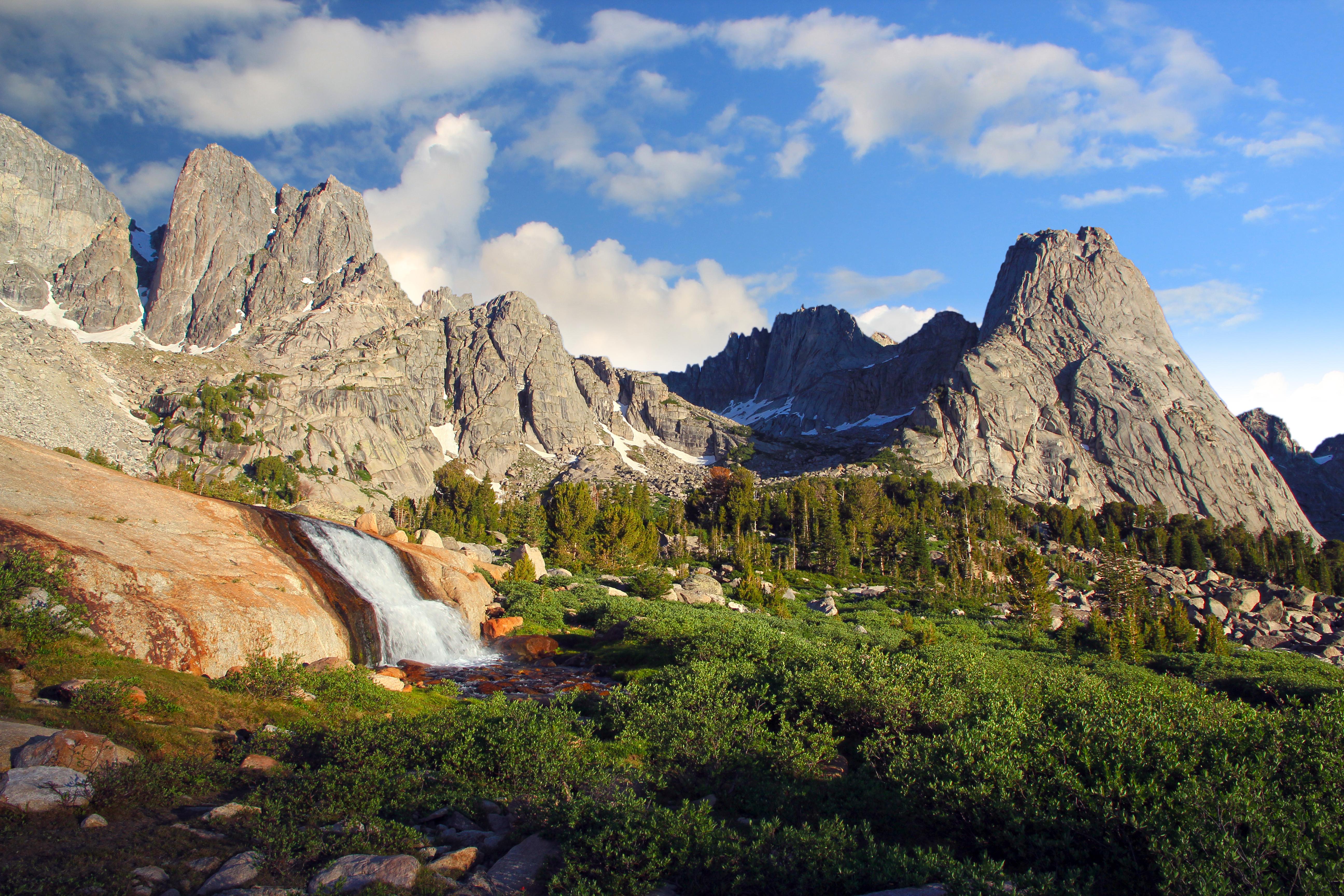
Day 3: (Wednesday). Especially assuming that I went and saw Pronghorn Peak on Tuesday afternoon or evening, then this is mostly just a day to keep moving. Pack up camp, backtrack through the East Fork Valley, and go over Hailey Pass to Baptiste Lake. This is only about 10 miles, but there's a fair bit of elevation gain and loss, so it could be a hard day, maybe. I'd love to get to Baptiste Lake early enough to spend the evening poking around the Baptiste cirque and basin a bit before nightfall, looking at the immense granite nearly 2,000 foot tall north face of Mount Hooker. If not, there'll be at least some time in the morning.
 |
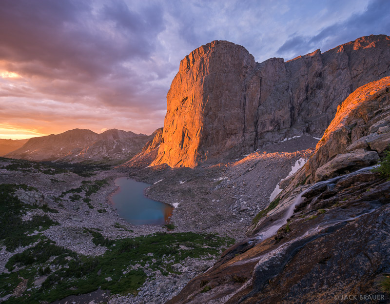
| Mount Hooker |
Day 4: (Thursday). This is a relatively short day, where I just have to leave the Baptiste Basin, ring the north shore of Grave Lake and set up camp somewhere in Ranger Park (presumably near Valentine Lake, but if I feel like it, I can set up anywhere in the area near a creek, stream or other lake. They're all close to each other.) Having a short and relatively flat day midway through the trip means I can take it easy and recover before I have to do a few more interesting days before finishing. It would also give me opportunity to explore a bit if I feel like doing that.
 |
| Valentine Lake |
 |
| Cirque of the Towers |
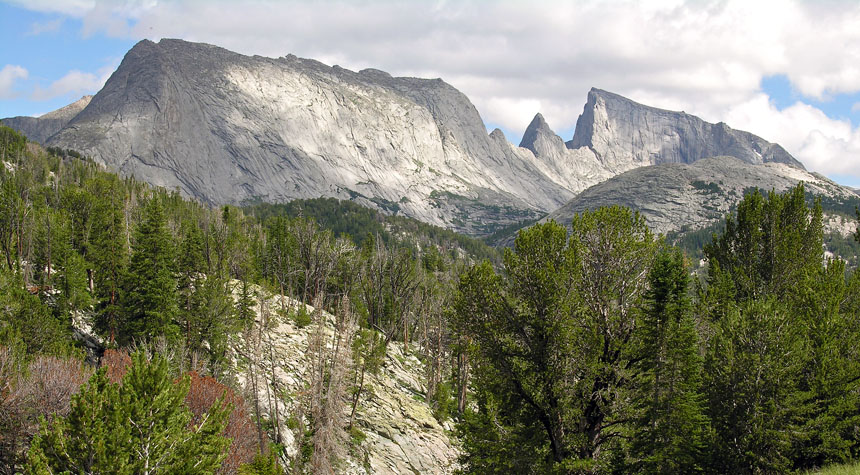 |
| L to R: Haystack, the Steeple, East Temple. Temple is just to the right of this shot. |
What I like about this itinerary: It's no more stretched out that my other one, but by dropping a lot of the weird out and back spurs and exploration (which I will miss, no doubt) I'll end up keeping my miles down to a manageable 10 or less per day (except for the first day, but I'll be fresh then, and it's also pretty flat.) I'll still need to make sure that I continue the training regime that I've started already to be ready for it, because at altitude and with a fair bit of elevation gain and loss, 10 miles a day is quite a bit more than 10 miles here at what is only a couple hundred feet or so above sea level on a flat sidewalk or gravel trail. I think of 10 miles as no big deal, but on rough trails, or even cross country, ranging up and down from just over 9,000 feet to right at 12,000 feet on my shortcut pass, it's quite a bit harder. I tried to keep big elevation gain days down in mileage; Day 2 and Day 5 have the biggest elevation gains, but I'm coming and going over passes many of the days.
I still see most of what I really want to see, even though I had to drop a few minor side trips. I still see the East Fork Valley. I actually added the Bonneville Lakes and Donna Lake stuff, because I hadn't realized that I was so close, and I think it's a shame to miss it if I'm literally right there. I still see Mount Hooker and the Baptiste Basin, and I still see Ranger Park, the Lizard Head approach and of course, the Cirque of the Towers; the real headliner attraction in the area. I've also added the East Temple stuff, after realizing that I can do that fairly easily too (although it'll mean another night in a tent).
What I don't like about this itinerary: I don't really like traveling or hiking so much on Sundays. I'd prefer to take a break and go to church. Maybe I'll actually have time to stop by a ward in Wyoming or Nebraska sometime for at least Sacrament Meeting without it putting me too far behind schedule on the way to the Wind Rivers. However, given my distance and the time involved to get to the area, it's probably a necessity that I use that time so I don't have to use extra vacation days to do the trip.
I also think that this may be pretty close to the limit of how long I could possibly want to be out in one trip. No matter how interested I am in seeing the Temple area, by the time I've already spent 5 nights in a tent, I may be more interested in being done than in seeing one more area, no matter how scenic and spectacular. Well, if so, I have that option; I can come straight from Jackass Pass to the car and skip the Temple area altogether, cut my trip one day short and still feel good about having done a challenging 55+ mile hike in some of the most beautiful country that we've got in America.
Monday, October 24, 2016
Archiving hiking plans for the GYE
EDIT: Added to pages, rather than as a post. See Pages list to the top right.
Thursday, October 20, 2016
Shoal Falls Loop
My wife has actually suggested that I fly to my next backpacking trip, rent a car, and go that way rather than drive out. I'm surprised, because this will no doubt be more expensive (and as the CFO of the house, the budget is kinda "her thing"). This is still early, and I don't know if it's going to be serious or not. I'm on the fence. I don't want to spend more money, even if it is "her job" to find it in the budget, it's mostly "my job" to make the money, and I'd kinda like to spend it somewhere else, I think. Plus, I don't care about putting more miles on my car; it's over five years old and just rolled over 100,000 miles a week or two ago anyway. But... if I do that, it buys me a couple more days. If I could fly out Friday afternoon or evening, leaving work a little early, but not so early that I need to spend more vacation time, I could potentially hike the Saturday and Sunday that I would have been driving there, and still get back early enough to save a vacation day on the tail end. Four days of driving is a big deal, and while I like a good road trip as much as the next guy, I admit that I wouldn't mind collapsing four days of travel just to get to my backpacking area of choice down to maybe a day of hanging out in airports, on planes, getting a rental car, and driving just a few hours from airports to trailheads.
What would I do with an extra two or three days or so? Well—the easy answer is that I can do the same trip and just spend less time away from home doing it, which is always an answer. But, maybe I can slip in another small trip to somewhere else that I'd really like to see in the area too. One option is the Shoal Falls Loop; a route that's more or less detailed in Backpacker Magazine and elsewhere, but at the same time, for anyone who knows anything about the area, it is pretty obvious. It hits the highest scenic high points of the Gros Ventre Wilderness in two simple days; or three if you take your time, or otherwise take a side-trip or two. While I admit that there are other places in the Gros Ventre that I'd like to see other that what this loop shows (Brewster Lake, the Six Lakes area, etc.) this is often considered a major scenic high point of the entire Jackson Hole area. And, of course, the big advantage is that it's short. And another advantage is that hardly anyone goes there. Compared to the Tetons or the Winds, it's empty. (The Winds can be empty when you get away from Cirque of the Towers and Titcomb Basin too, of course...)
I've whipped up a Caltopo for this trip that includes the entire loop as a single route, including a couple miles or so of an exploration of nearby Deer Ridge that offers tremendous views of the area and comes highly recommended. I've marked three potential campsites, but Campsite #2 at Shoal Lake is the one I'm most likely to want to do. Unless Deer Ridge ends up taking more time than I think.
I've also added a spur hike to Brewster Lake; a potential day hike if I set up camp at Shoal Lake and stay there two nights. I doubt I'd do this, but it's worth noting as an option anyway. If I do, it makes it much more likely that I'd be "done" with the Gros Ventres for some time; why go back when I've seen all of the must-dos and I have so many other places still to explore in the West?
Here's a few images I've found online here and there.
 |
| Doubletop Peak from Deer Ridge. Doubletop is the range high point. |
 |
| Palmer Peak from Deer Ridge |
 |
| High pond on the route |
 |
| Shoal Lake |
 |
| Black Peak with summer wild flowers |
Wednesday, October 19, 2016
Further exploration of potential Wind River routes
I continue to tinker with ideas, although I was quite happy with the "lollipop" loop that I'd constructed to go from Big Sandy to the Cirque of the Towers, and then loop around and see more of the Wind River range. In a perfectly ideal world, I'd have the entire month of August to explore the GYE, and I'd do this hike in it's most expansive iteration, plus my Beartooth loops, a big loop of the Gros Ventre range, and a hike of the Teton Crest Trail... with a couple nights in the Teton Lodge to do laundry, rest up in a real bed and eat some nice food in between excursions into the backcountry. In the real world, I'll do—most likely—this Winds hike, with some version of the Beartooth hike as first alternate. Tetons is right out if I don't even get around to applying for a permit, which this year I almost certainly won't.
So, I've made some minor tweaks to the itinerary, in an attempt to see more of the places I've mapped out with as little backtracking as possible. My schedule is somewhat constrained, but not so much that it'll be a major show-stopper. To take as little time off work as possible, I have to make Saturday and Sunday be driving days. I leave Saturday in the morning, get to somewhere in the middle of Nebraska that night, and then get to the Big Sandy campground by evening on Sunday. Given past experience in driving to Vernal, UT, which is not exactly the same direction after leaving Nebraska, but which is the same mileage and time, give or take a small amount, I should not have any trouble arriving before dark, setting up camp, and getting a good night's sleep at the Big Sandy campground before starting the hike.
On the other hand, if my wife really does encourage me to fly out, then I have even more flexibility on which days of the week are what.
Day 1: Skip the Cirque of the Towers the first time around. If I go during my enforced "shutdown" week, it'll be July 3rd, and the place will be crazy busy (although I'd like to do something else that week and go in mid-August when conditions are almost certain to be better in the mountains.) Take the alternate Fremont Trail instead on the west side of Laturio Mountain. The ideal, although given that it's the first day I may not be up for quite this much hiking—would be to get all the way to Pyramid Lake on Day 1. This cuts an entire day off my itinerary from the former plan (although I'll use it later with day trips and whatnot) and means that I don't brave the famous Cirque of the Towers until near the end of the trip, when hopefully the holiday crowds will have cleared out. Miles so far: 12.3. If I don't make it all the way to Pyramid Lake for whatever reason, I can stop at Marm's Lake or Skull Lake instead, or even Dad's Lake in a real pinch. I don't know why I wouldn't unless altitude acclimatization tires me out a lot faster than I think it will (which did happen to some degree the last two times I was in the Uintas) but honestly, if that's going to be a major issue at this point, it'll probably cause more problems for the entire itinerary than simply getting to Pyramid Lake the first day, and I'll have to do more in the way of cuts. On the other hand, if I can do more miles and have a good, strong, first day, then I can take the little black extension off-trail to go see the magnificent Donna Lake with it's bizarrely shaped Pronghorn Peak. If I get myself in decent shape before going, and start nice and early first thing in the morning, that's not completely out of the question.
Day 2: Get up in the morning and explore the adjacent East Fork Valley (of which I've seen stunningly beautiful pictures on Google Maps.) I've heard some others call this Desolation Valley as well, but it's the East Fork Creek watershed, so I suspect that's the proper name for it. This is 3 miles one way (as mapped on Caltopo; in reality, it's just wandering around until I've seen as much as I want.) Pack up camp and take the relatively short hop over Hailey Pass and set up again at Baptiste Lake. Admire the massive rock wall of Mount Hooker, maybe even watch some climbers given that it might be July 4th and people will be off work. Shake my fist at the arbitrary line that divides the lake and the valley overall between the Shoshone National Forest and the Wind River Indian Reservation. (Probably) refrain from trespassing onto the reservation. Miles so far: 24.03 although half of day 2's miles are without a pack, so they'll be a ton easier.
Day 3: Backtrack back to the Bears Ears Trail, go around the north end of Grave Lake to Ranger Park, and go off-trail beyond Valentine Lake to South Fork Lake to set up camp, a relatively shorter day of 9 miles (although I'm given to understand that beyond Valentine Lake the going might be a little tough, but worth the trouble.) Miles so far: 32.8

Day 4: Before breaking camp, go explore the valley to the west, and climb up to the summit of Washakie Pass on the Continental Divide. Take pictures, enjoy the views both directions of the east and west sides of the divide and the nearby peaks, including Mount Washakie itself, for which the pass is named. Head back to camp and take it down, and then take a short jaunt around Cathedral Peak towards the Cathedral Lakes, to set up the next camp. The day hiking portion is just short of 5 miles one way, so it'll take a fair bit of time (until early afternoon, no doubt) to do, but the rest of the trip to my proposed Cathedral Lakes campsite is only a little under five more miles. This makes for a long day of walking, but I've only got my pack for a third of the distance. If it seems like too much, the Washakie basin exploration can be cut somewhat shorter and lop a few miles off the total. That's just for scenic appreciation anyway. Miles so far: 47.89.
Day 5: Bushwhack back around the Cathedral Peak massif and get back on the trail. Head south on the Lizard Head Trail around Lizard Head Peak and into the Cirque of the Towers from the northeastern entrance. This may be a long day, so if I stop early at Lizard Head Meadows, that'd be fine. Otherwise, go all the way to Lonesome Lake. This is a 12½ mile day, with nearly three of that bushwhacking what may be rough country, so that's fine. Miles so far: 60.42.
Alternate Day 5: If the bushwhack is rather rough, and I have at least one guy who said that it was, this is an on-trail option that gets me to the same entrance to the Cirque without the bushwhack. It's a little longer, but it's all on trail. It depends on whether I'd rather add 3-4 miles, or brave the bushwhacking. In an ideal world, I'd go check out the High Meadows hanging valley while I'm at it, but I almost certainly won't have time for that. It's a real shame; it looks intriguing on the topo.
Day 6: Completely unscripted exploration of the Cirque of the Towers without moving camp. I have no idea how many miles I'll walk this day, because it's just an exploration of whatever I feel like looking at. Walk around Lonesome Lake. Look for waterfalls and streams. Maybe walk all the way east to Papoose Lake, or Cirque Lake and the other lakes up near Texas Pass, etc. Maybe even get to the top of Texas Pass to look on the other side. By this point, my purpose is to kill time, relax a bit, enjoy one of the most scenic places in the United States and rest up for a long hike out (which, luckily, is mostly downhill after going over Jackass Pass, though) the next day. Because the exploration is unscripted, I have no idea how many miles I'll actually cover but I whipped up an estimate in Caltopo that I'll probably log about 10-12 miles. Miles so far: ~71.
Day 7: Hike back to the car. About 9 miles over Jackass Pass, and then all downhill and supposedly easy walking. Should be back to the car early enough to get into Pinedale or Lander or somesuch, clean up in a hotel and eat at a restaurant for the night, before heading back home. Total hiked miles: ~80.
This completes an entire week of vacation, including the bookend weekend days, but I still need an additional 2 days to get back home, so that'll have to happen Monday and Tuesday, and have me back at work by Wednesday; because July 4th is a holiday, that means I only need to take 6 vacation days to make this trip happen.
Hotlinking images from Jack Brauer photography. I'm not actually grabbing or saving the images, just linking to them at their original site. See them in their original context here: http://www.mountainphotographer.com/in-the-winds/
So, I've made some minor tweaks to the itinerary, in an attempt to see more of the places I've mapped out with as little backtracking as possible. My schedule is somewhat constrained, but not so much that it'll be a major show-stopper. To take as little time off work as possible, I have to make Saturday and Sunday be driving days. I leave Saturday in the morning, get to somewhere in the middle of Nebraska that night, and then get to the Big Sandy campground by evening on Sunday. Given past experience in driving to Vernal, UT, which is not exactly the same direction after leaving Nebraska, but which is the same mileage and time, give or take a small amount, I should not have any trouble arriving before dark, setting up camp, and getting a good night's sleep at the Big Sandy campground before starting the hike.
On the other hand, if my wife really does encourage me to fly out, then I have even more flexibility on which days of the week are what.
Day 1: Skip the Cirque of the Towers the first time around. If I go during my enforced "shutdown" week, it'll be July 3rd, and the place will be crazy busy (although I'd like to do something else that week and go in mid-August when conditions are almost certain to be better in the mountains.) Take the alternate Fremont Trail instead on the west side of Laturio Mountain. The ideal, although given that it's the first day I may not be up for quite this much hiking—would be to get all the way to Pyramid Lake on Day 1. This cuts an entire day off my itinerary from the former plan (although I'll use it later with day trips and whatnot) and means that I don't brave the famous Cirque of the Towers until near the end of the trip, when hopefully the holiday crowds will have cleared out. Miles so far: 12.3. If I don't make it all the way to Pyramid Lake for whatever reason, I can stop at Marm's Lake or Skull Lake instead, or even Dad's Lake in a real pinch. I don't know why I wouldn't unless altitude acclimatization tires me out a lot faster than I think it will (which did happen to some degree the last two times I was in the Uintas) but honestly, if that's going to be a major issue at this point, it'll probably cause more problems for the entire itinerary than simply getting to Pyramid Lake the first day, and I'll have to do more in the way of cuts. On the other hand, if I can do more miles and have a good, strong, first day, then I can take the little black extension off-trail to go see the magnificent Donna Lake with it's bizarrely shaped Pronghorn Peak. If I get myself in decent shape before going, and start nice and early first thing in the morning, that's not completely out of the question.
Day 2: Get up in the morning and explore the adjacent East Fork Valley (of which I've seen stunningly beautiful pictures on Google Maps.) I've heard some others call this Desolation Valley as well, but it's the East Fork Creek watershed, so I suspect that's the proper name for it. This is 3 miles one way (as mapped on Caltopo; in reality, it's just wandering around until I've seen as much as I want.) Pack up camp and take the relatively short hop over Hailey Pass and set up again at Baptiste Lake. Admire the massive rock wall of Mount Hooker, maybe even watch some climbers given that it might be July 4th and people will be off work. Shake my fist at the arbitrary line that divides the lake and the valley overall between the Shoshone National Forest and the Wind River Indian Reservation. (Probably) refrain from trespassing onto the reservation. Miles so far: 24.03 although half of day 2's miles are without a pack, so they'll be a ton easier.
Day 3: Backtrack back to the Bears Ears Trail, go around the north end of Grave Lake to Ranger Park, and go off-trail beyond Valentine Lake to South Fork Lake to set up camp, a relatively shorter day of 9 miles (although I'm given to understand that beyond Valentine Lake the going might be a little tough, but worth the trouble.) Miles so far: 32.8
Day 4: Before breaking camp, go explore the valley to the west, and climb up to the summit of Washakie Pass on the Continental Divide. Take pictures, enjoy the views both directions of the east and west sides of the divide and the nearby peaks, including Mount Washakie itself, for which the pass is named. Head back to camp and take it down, and then take a short jaunt around Cathedral Peak towards the Cathedral Lakes, to set up the next camp. The day hiking portion is just short of 5 miles one way, so it'll take a fair bit of time (until early afternoon, no doubt) to do, but the rest of the trip to my proposed Cathedral Lakes campsite is only a little under five more miles. This makes for a long day of walking, but I've only got my pack for a third of the distance. If it seems like too much, the Washakie basin exploration can be cut somewhat shorter and lop a few miles off the total. That's just for scenic appreciation anyway. Miles so far: 47.89.
Day 5: Bushwhack back around the Cathedral Peak massif and get back on the trail. Head south on the Lizard Head Trail around Lizard Head Peak and into the Cirque of the Towers from the northeastern entrance. This may be a long day, so if I stop early at Lizard Head Meadows, that'd be fine. Otherwise, go all the way to Lonesome Lake. This is a 12½ mile day, with nearly three of that bushwhacking what may be rough country, so that's fine. Miles so far: 60.42.
Alternate Day 5: If the bushwhack is rather rough, and I have at least one guy who said that it was, this is an on-trail option that gets me to the same entrance to the Cirque without the bushwhack. It's a little longer, but it's all on trail. It depends on whether I'd rather add 3-4 miles, or brave the bushwhacking. In an ideal world, I'd go check out the High Meadows hanging valley while I'm at it, but I almost certainly won't have time for that. It's a real shame; it looks intriguing on the topo.
Day 6: Completely unscripted exploration of the Cirque of the Towers without moving camp. I have no idea how many miles I'll walk this day, because it's just an exploration of whatever I feel like looking at. Walk around Lonesome Lake. Look for waterfalls and streams. Maybe walk all the way east to Papoose Lake, or Cirque Lake and the other lakes up near Texas Pass, etc. Maybe even get to the top of Texas Pass to look on the other side. By this point, my purpose is to kill time, relax a bit, enjoy one of the most scenic places in the United States and rest up for a long hike out (which, luckily, is mostly downhill after going over Jackass Pass, though) the next day. Because the exploration is unscripted, I have no idea how many miles I'll actually cover but I whipped up an estimate in Caltopo that I'll probably log about 10-12 miles. Miles so far: ~71.
Day 7: Hike back to the car. About 9 miles over Jackass Pass, and then all downhill and supposedly easy walking. Should be back to the car early enough to get into Pinedale or Lander or somesuch, clean up in a hotel and eat at a restaurant for the night, before heading back home. Total hiked miles: ~80.
This completes an entire week of vacation, including the bookend weekend days, but I still need an additional 2 days to get back home, so that'll have to happen Monday and Tuesday, and have me back at work by Wednesday; because July 4th is a holiday, that means I only need to take 6 vacation days to make this trip happen.
Hotlinking images from Jack Brauer photography. I'm not actually grabbing or saving the images, just linking to them at their original site. See them in their original context here: http://www.mountainphotographer.com/in-the-winds/
Tuesday, October 18, 2016
Possible Wind River excursion
I've been kicking around an exploration of the Beartooth mountains for the summer of 2017, but some of my other routes are still in play. I'm also extremely interested in the Wind Rivers; as the other GYE range that is made of a gigantic eroded pale, Sierra Nevada-like granite batholith, the two have similar features to recommend them. The Wind Rivers are, if anything, perhaps a bit less likely to put you face to face with a grizzly (not that it's likely in either range, but the spread of grizz's in the Winds is still light, and mostly focused on the north of the range) and a bit more craggy and serrated in general. I could happily do either of these routes this summer, and enjoy them probably equally. In spite of my momentum towards the Beartooths as I've investigated them the last few weeks, I'm almost leaning more towards the Winds already at this point. Here's how this route would look. The camp sites are provisional, and may end up being moved; the two spurs in particular can be cut off if needed to shorten the drip by about a day.
Most good Wind River hikes start at one of three trailheads; Green River Lakes, Big Sandy or Elkhart. This one makes it's debut in the middle of those; the Big Sandy trailhead, which looks something like this: http://brettsimison.photoshelter.com/image/I00004sF5MvXB1yo

Going to the Wind Rivers, if you've never been there before, absolutely cannot miss seeing at least one of the two banner locations to visit: Cirque of the Towers or Titcomb Basin. The former is to the south, and is the goal of the first day of backpacking on the route I've mapped up here. My goal would be to arrive at the trailhead by nightfall after driving from out east for two days, and car camping the first night, giving me a great full day to do the first leg of the backpacking trip. Over the course of just shy of nine miles, the route for this first day gains a gross almost 2,000 feet of elevation—a relatively modest gain, but big enough, especially for your first real day in the high country, that you'll want to be in at least halfway decent shape to do it. The steepest portions of the trail are entering the mountains proper after Big Sandy Lake, and then going over the pass that takes you into the Cirque. After this hike, you'll spend the night in the famous Cirque; hopefully without too much in the way of crowds. We'll see.
The next day, assuming that I'm too anxious to keep moving to spend another day exploring the cirque, has me going over Texas Pass to Pyramid Lake. Although not as famous for its grandeur as the cirque, pictures of the area are still stunningly beautiful... and it has another advantage; it's not a climber's Mecca like the cirque is. And after going over the pass, the rest of the day is relatively flat, which is also nice.
After spending the night at Pyramid Lake, I go over Hailey Pass and head towards Baptiste Lake, where you can see the north face of Mt. Hooker. How can you miss that? It makes for a short Day 3, but with a big pass to climb, and being that it's the third day, I'd like to take it easy and have a little time to explore the Baptiste Basin a bit. The next day, I backtrack back to the main trail and go by incredibly scenic Grave Lake before continuing on past Valentine Lake, the last little bit off trail to the South Fork Lakes. The next day, the penultimate, has me summiting Washakie Pass before closing the loop portion of the lollipop and spending the night at Shadow Lake, just shy of Texas Pass again. And the final day ends up being one of the longest in terms of miles (12) but much of it is downhill—although I do have to enter the Cirque again, and then cross another pass to get out of it. If I decide to take it just a bit easier on the home-stretch, I could further explore the cirque, and head east a bit towards Lizard Head Meadows.
I have to be careful not to get too ambitious, however. I've discovered about myself that in the comfort of my office planning these trips on my PC, that I often get really excited about rambling all over the countryside and seeing all kinds of things... only to discover that when my boots actually hit the ground that I have an effective limit of 4-5 nights before I'm kind of tired of eating trail food and sleeping on the ground. So my trip is already on the upper limits of what I tend to like doing. I've kept the days to 10-12 miles of hiking (or less) as much as possible, in an attempt to keep myself from getting too worn out, but I'm also seeing what I can do to get into better shape between now and the time I go, so maybe that won't be as much of an issue as it was in the Uintas (especially the elevation gain.)
I've also added an alternate short-cut loop that takes the Bears Ears Trail to the Lizard Head Trail and comes back to the Cirque of the Towers from the northeast. The intent is that this would be taken at Valentine Lake rather than heading west southwest across Washakie Pass. There are, of course, vaorus other methods of combining the legs of the loops into various potential short-cutted options. No matter what you choose, unless you spend more time than I am likely to be willing to spend, plus some not insignificant back-tracking, you have to miss a part of the Winds that I'd really love to see.
Sigh. Isn't that always the case? I've also, just for the heckuvit, added a nearly 3 mile (one way) day hike exploration spur up the Bonneville Basin. Given the very short day planned for Day 3 (which starts at the same place) this may not necessarily be an unreasonable side trip, depending on what kind of time I'm making in general on this trip.
Tuesday, October 4, 2016
Well, crap...
http://phx.corporate-ir.net/phoenix.zhtml?c=177739&p=irol-newsArticle&ID=2208410
Cabela's to be bought by Bass Pro Shops. Bass Pro Shops isn't a chump group, but they're no Cabela's. I don't know if they're buying Cabela's for the market share, or for the brands. I hope it's the latter, in which case, I can expect to see stuff continue as is (or at least similar to what it is) for some time.
I wear Cabela's jeans, Cabela's cargo pants, Cabela's socks, Cabela's jackets, Cabela's shoes for work, and Cabela's boots for hiking. If in the future when I need to replace what I have, I can't get Cabela's, I'm probably going to have to go with some snooty, smug, self-righteous (and most especially) over-priced alternative. Rail Riders for pants? Patagonia? The North Face? Am I going to have to buy them at REI? Blegh.
Not happy today.
Tuesday, September 27, 2016
Beartooths Part Deux
Well, I got that caltopo made quicker than I thought. Here's the skinny:
Part I: The "stick" of the lollipop for the Bear's Tooth hike is the easternmost red section. At 5.07 miles and nearly 1,500 feet of elevation gain, this might be the better part of a day, depending on how early I can get to the trailhead.
Part II: The purple loop is the exploration of Black Canyon Lake and the country all around Beartooth Mountain itself, including Spirit Mountain and Sky Pilot Mountain, numerous lakes, a lot of climbing (especially over that pass at Beartooth Mountain) and essentially no trail at all to speak of for most of the route. At 13.78 miles, and with nearly 5,000 of elevation gain, this is either a very long, hard day, or better yet, I'll stop somewhere partly through it at one of those lakes.
All in all, I see this lollipop taking 2½-3 days. The total mileage is Part I x 2 + Part II, or 23.92 miles. Not a bad little loop.
Part III: Assuming that I'm starting this fairly late, after doing the loop above, this is the "stick" of the second lollipop. It's 9.51 miles long, and gains over 3,000 feet of elevation gain itself, so it's not a picnic, exactly. I would tend to see it as the better part of a day's hike by itself; if I can't start 'til late, I need to camp somewhere inside the trail; maybe at either Elk or Rainbow Lake. If it's really late, I can always camp right there near the trailhead at Rosebud Lake somewhere.
Part IV: At 18.73 miles, this is the real meat of the whole trip. Continue on the "Beaten Path" trail to Fossil Lake at which point you break cross country to get to the Aero Lakes, go through the valley between Mount Villard and Cairn Mountain, have a good, up-close look at Granite Peak (the highest in Montana!) before heading back down to Big Park Lake and rejoining "the stick."
Part V: This little spur is completely optional, but goes up the hanging valley to the wonderfully scenic Martin lake, Glissade Lake, etc. The climb up to the hanging valley is supposed to be pretty brutal, but once you're there, it's not too bad. At only 3.11 miles, this is just either a day trip, or a nice, secluded camp site if I start it in the afternoon.
In total, this second lollipop is 43.97 miles (37.75 if I forego the optional hanging valley spur) which is still a good 4½-5 days. Both hikes together are, at a minimum, 6½ days, more likely 7½ or 8. That's a long time in the wilderness (I tend to find that after 4-5 days, I sometimes have had enough and am ready to come back) but after missing 2016, and assuming that I've been successful in getting in better shape before starting this year, it'll be doable. Plus, that means that I won't need to worry too much about coming back this way anytime soon, and I can see something else in 2018's summer.
The Beartooths
It looks like the Greater Yellowstone Ecosystem is on my radar again. Now I've got two contacts that aren't too far away, and one in particular that looks promising as a "staging area"—so rather than taking my summer 2017 trip in the Uintas again, which I've blogged about here probably ad nauseum, I'm thinking of a GYE hike. I'm really spoiled for choice in the GYE, but I've kind of focused on four areas as "highest priority" for the area that would trump all other potential options; at least until their done:
From the attached/linked map, you can see that the purple route can rather easily be converted into a lollipop by simply ignoring the second half where you go over Sundance Pass, up West Fork Rock Creek and up onto Rosebud Plateau to get to Rosebud Trailhead, and heading back to the Lake Fork Trailhead from Keyser Brown Lake. It's a bit of a bummer, but it's really Black Canyon lake, the actual Bears' Tooth, and then while I'm at it, since I'm so close, Sky Pilot Mountain that I want to see on that hike. The second half was more about linking the two routes than because anything on the second half was really a "must see."
- The Teton Crest Trail
- The Wind Rivers, including Titcomb and Indian basins, and Cirque of the Towers.
- An exploration of the Gros Ventre; the least ambitious option is only a night or two in a tent; the most ambitious is a good week and a half
- The Beartooths
I'm thinking of applying for Teton Crest Trail permits in my window and if I get it, then doing that (a probably 3-5 night outing, so I could do a minimalist Gros Ventre hike maybe as part of that trip) but if I don't—and I think that's the most likely, then I need to have a Plan B (which in many ways is actually the Plan A.) And for this, I find myself leaning towards the Beartooths.
I long ago came up with a caltopo map that shows a bunch of stuff in the area, and with the exception of marking the Sphinx and Helmet Trailheads, it's all right there in the Beartooths. However, I don't think these routes would work for me without a bit of modification. For the most part, they're point to point hikes (Lake Fork Trailhead to Rosebud Trailhead and Rosebud Trailhead to Cooke City/Colter Pass—which is the so-called "Beaten Path" route.) In addition to the point to point hikes, I've added a few options, but all of them require some kind of car shuttling. While it's not impossible that I could have access to easy car shuttling, I'd much rather be able to do all this independently on my own, which requires making loops out of these hikes. I'll need to spend some work and time on figuring out what the "greatest hits" of the Beartooths are, in that case.
From the attached/linked map, you can see that the purple route can rather easily be converted into a lollipop by simply ignoring the second half where you go over Sundance Pass, up West Fork Rock Creek and up onto Rosebud Plateau to get to Rosebud Trailhead, and heading back to the Lake Fork Trailhead from Keyser Brown Lake. It's a bit of a bummer, but it's really Black Canyon lake, the actual Bears' Tooth, and then while I'm at it, since I'm so close, Sky Pilot Mountain that I want to see on that hike. The second half was more about linking the two routes than because anything on the second half was really a "must see."
The "Beaten Path" (the Red Route) can be converted into a lollipop easily as well; if I follow it as far as Fossil Lake, which is almost all of the dramatic portion of the scenery, I can then hop on the light blue route (all of which is actually off trail, although I'm given to understand that use trails make up some of the route) I can rejoin the "stick" of my lollipop near Big Park Lake. I could even do the green option at this point if I'm not exhausted from all of this hiking and all of these days in the mountains at this point, although I've been told that the pass between Snowbank Mountain and Point 11,848 (that connects Bergschrund and Summit Lakes) is not a fun one; I might do either of those hanging valleys as spurs and not try to link them; assuming I do either of them at all.)
Later when I have more time, I might whip up a caltopo of those two proposed routes and see how many miles it really is. But for now, it's reasonably easy to see what I'm talking about based on the map above.
Sunday, September 4, 2016
Uintas "Alpine" Traverse
I've been tinkering a bit in Caltopo with what I call the "Alpine Traverse" of the Uintas. For those who may not have read any of my earlier posts, here's the High Concept of this hike: the Uintas, if you look at the entire range in satellite view, look like a rugged green tadpole with a kink in the tail. The Uintas are an interesting range, and I often divide them into three sections that have three very distinct characters (summitpost.org divides it into four, but two of them are more distinguished by land use differences rather than by actual physical characteristics per se); I've described my divisions in this post. It's worth pointing out, however, that even my section C can be pretty fairly divided in half, at the Green River Canyon. Looking at the satellite image, on the east of the canyon the mountains are very desert-like in nature, while west of the canyon, up until we get to my section B, they are semi-desert, gradually starting to change into the more alpine forested High Bollies or Flaming Gorge section. Section C between the section B boundary and the Green River canyon is therefore a hybrid between the more overt desert and the more overt mountain forest.
What does all of that mean? Well, relative to my own potential hiking plans, it means a few things. First, the season in which to hike the alpine section of the Uintas does not coincide well with the season to hike the desert section of the Uintas. What is great for the alpine section is terrible for the desert section because it's too hot and dry in the desert, whereas what is great for the desert section is terrible for the alpine section, because it'll be when snow is heavy on the ground in the alpine area. Therefore a traverse of the entire range becomes somewhat impractical, or at the very least, undesirable. I would much rather stick with the alpine section and leave the desert off. As it happens, it's easy to jump on at the Green River canyon, at the so-called Gates of Lodore Ranger station (to be technical, right across the river from it) and hike my transition section into the High Bollies, and then all the way across the alpine High Uintas area.
So, I've been twiddling around with what I call the "Alpine Traverse" of the Uinta Range, leaving off only the most dry little tadpole tail rump of the eastern desert mountains untouched (as well as a foot traverse of the Green River canyon itself, which I'm not 100% sure is doable.) This is still a pretty epic hike; it nearly doubles the official complete length of the actual Highline Trail, which is 96 miles—but how close to doubling depends on a number of potential options, scenic detours, and other potential diverges. The longest the route could possibly be is 196 miles. But it could also be as short as 161 miles and still be considered "complete." What are the various options? I've divided the route up in Caltopo into various segments, numbered 1-8 (going from east to west, although it could also be reasonably hiked the other way too, I suppose) with other labels for some of the other spurs, detours and alternate routes. Let's have a look, shall we?
Segment 1: This is the starting point at Gates of Lodore, and requires a fair bit of bushwhacking through the scrubby semi-desert until you get to Allen Draw. Allen Draw is the terminus of this section, and Allen Draw is actually (relatively) easily reached by the road that goes through Crouse Canyon, so it represents a kind of alternative starting point. But if you want to catch the Gates of Lodore experience, this segment will add nearly 16 miles—probably a good two days given the bushwhacking, although maybe it can be done in less time—of more of the transition between the Dinosaur National Monument terrain to the Flaming Gorge/High Bollies terrain. Because it walks to the alternate eastern terminus, it becomes completely optional, and the hike can be easily done without it. Except for a fairly steep initial climb, it's relatively flat, once you get up on Diamond Mountain.
Segment 2: This segment, on the other hand, is part and parcel of the entire concept of the expanded hike; that is, to add a bunch of the Flaming Gorge alpine and semi-alpine miles to the total. Whether you drive through Crouse Canyon to Allen Draw, or hike from the Gates of Lodore, either way, this is just over 27 miles that can't be missed without abandoning the high concept of the hike altogether. Combined with Segment 1, this adds over 43 miles to the Highline Trail. Admittedly, a fair bit of this segment is on rinky-dink dirt roads rather than trails, which may not appeal to many. On the other hand, this is a very little used area of the range, and it also has a not insignificant number of miles of bushwhacking.
Segment 3: 2 ends at the official eastern terminus of the Highline Trail (albeit, that far eastern leg is rarely done—even after a big effort at trail clean-up and maintenance from the nearby town of Vernal. This is also a potential spot for a food drop, as is the western portion of this section, Chepeta Lake—the last road before you really dive straight into the High Uintas Wilderness. Chepeta Lake is also the most westerly "eastern terminus" that you can hike and really credibly claim to have hiked the Highline Trail; although many people consider themselves as having hiked it if they do the Hacking Lake TH midway through this section. This is almost 37 miles long; nearly as long as the entire two sections before it, and it gradually transitions from the Flaming Gorge character of its eastern edge to the High Uintas true alpine nature at the western edge. By Chepeta Lake you will have hiked, if you do all three segments, 80 miles, and you're close enough to the midway point to count it as a potential celebration. If you hike fairly quick, you can probably make this your only food drop (or if you carry an awful lot of food). If you average somewhere between 10-12 miles a day, you will have taken a complete week to get this far. You'll also have eased yourself somewhat into the higher elevations, above tree-line alpine tundra that you'll face for much of the next section, and will have gone over a few good passes.
Segment 4: From Chepeta Lake, this goes to the Smith's Fork Junction deep in the High Uintas wilderness. It also will have taken you over Anderson Pass, less than a mile from the summit of King's Peak, the state high point in Utah. Few consider that a natural place to end a segment, except that at the junction, you need to make a decision; to stick with the official Highline Trail (a shortcut) or take a scenic detour to see the Red Castle area while you're at it. This crosses two big passes, North Pole pass in the east and then after crossing Painter Basin, Anderson Pass. There's pretty big elevation gain to summit these passes, but otherwise, you spend a great deal of time in Painter Basin (and then Yellowstone Basin) enjoying relatively flat and scenic views of unobstructed alpine tundra, with forest only in the very lowest portions of the river valleys. At 29 miles, this is a good two and a half or even closer to three day section, probably—especially when you consider the summit spur option below.
King's Peak Summit Spur: This is optional, but hardly anyone who hikes the Highline opts not to summit King's Peak while they're right there. It's just an up and back, 1.5 miles round trip. The summit is just under 1,000 higher than the Anderson Pass summit, and there's reportedly an easy to follow social trail to the top.
Segment 5: My default route includes this and the official Highline as an unofficial shortcut, but of course, most people hiking the Highline would consider it the opposite. This is 11.5 miles where you turn off of the Highline in Yellowstone basin and summit Smith's Fork pass instead into the Smith's Fork basin. Keeping going north and then west to round the horn of the Red Castle massif, probably spending a night at Lower Red Castle Lake, which is one of the scenic highpoints of the entire range. Going back south (and up again) over the pass behind Upper Red Castle Lake (which isn't labeled on my map or on Caltopo, but which I've often heard called Wilson Pass because of nearby Wilson Peak) you can get back on the Highline nearly right away in the "Oweep Basin." There isn't a marked trail over this pass, but scuttlebutt is that much of the route is actually a social trail, with relatively little route-finding/scree-whacking required. Although there is some.
Alternate shortcut: On the other hand, if you just stay on the Highline and ignore the allures of the Red Castle area, you knock nearly 6 miles off of your route—at least half a day, maybe more if you spend some time actually enjoying the Red Castle scenery. You cross Porcupine Pass from the upper western Yellowstone Basin into the upper Eastern Lake Fork Basin (this spur is often called "Oweep Basin" because Oweep Creek runs through it.) This is a super scenic pass in its own right, although you get similar views from "Wilson Pass". If you do the Red Castle option, you will have hiked 122 miles by the end of this section, and if you hike this shortcut instead, you're still at 116 or so miles.
Segment 6: This 16 and half mile section mostly follows the Highline up and over Red Knob Pass and to Dead Horse Lake, where there's again a choice to be made. It does include a very small detour from the main route to see Crater Lake, though—the deepest lake in the Uintas and one to which no trail (and therefore extremely few hikers) goes to. The top of Red Knob Pass looking into the West Fork Blacks Fork (Dead Horse) Basin is one of the most scenic views in the entire range.
Segment 7: 22 mile segment 7 is closer to the official Highline Route. However, even it has a few detours, including the "north trails" detour that most hikers use in the Rock Creek Basin to see all of the lakes along the edge of the basin, like Helen, Lightning, Gladys, and Rosalie Lakes. I have a little off-trail detour to see several lakes in a very small sub basin in the upper northeast portion of Rock Creek; Boot Lake, Jodie Lake, Doug Lake, Reconnaissance Lake, and Triangle Lake. Once you get back on the Highline, you cross Rocky Sea Pass and continue on to the official western terminus of the Highline Trail... but of course, the concept of this hike is that that's not the end.
Alternate Northside Route: This alternate is actually shorter than Segment 7 by about 4 miles, but is probably much more difficult, given that instead of crossing two passes, you're going over twice as many... all without trails. I know that it's doable; I've seen trip reports of hikers who have hiked all of these sections (although not strung together like this). Although it misses Dead Horse Pass and the scenic Rock Creek Basin, at the same time, the North Slope basins here are almost uniformly considered among the most scenic in the entire range; Allsop, Priord/Norice, Amethyst and Middle Basins. The western edge gets relatively more traffic, because they're closer to the Mirror Lake Highway, and relatively easy to reach, but that's still relative. I'm a little unsure about this; it depends on my confidence and condition while hiking a putative through-hike of this route, if I take this or opt for the more standard route of Segment 7.
Packard Lake Spur: This small spur; just a mile and a quarter one way (which has to be hiked back again (would be a desirable camp site if doing Segment 7 that's off the beaten path a bit, and gives a great view of the very scenic East Fork Canyon; a small spur canyon that joins the Duchesne River canyon. You can get great views of the latter too if you go off trail from Packard Lake and pole around the edge of the canyon rim near the eastern edges of Wyman and Wilder Lake spurs. If I do Segment 7 instead of the Alternate Northside Route, I'll absolutely stop here. I'm actually more likely to stick with the official route of Segment 7 rather than my more ambitious Alternate, but either one that I pick, I'll be disappointed in missing the other.
Segment 8: 25 mile Segment 8 is linking trails with a few minor spots of bushwhacking to see the western end of the Uintas beyond the Highline Trail. There's a lot more usage of this area, because it's closer to the Mirror Lake Highway and easy to get to; in fact, you will actually have to walk along the MLH for a small distance (three quarters of a mile.) While its usually considered less dramatic than the actual wilderness area to the east, there's a lot of really beautiful spots here, and this route is designed to try and see some of the most important of them. At the end of the segment, you have to decide which finishing spur you'll use. The one that goes to the Yellow Pines trailhead is probably what I'll do, as it's easier both to hike and to leave a car.
Terminus Spur: At just shy of 4 miles, this is just the last afternoon of hiking to get from Yellow Pines lakes to your car. You won't see anything really dramatic here (I don't think) except for trees. But it has to be done to get to your car. On the other hand, the other option was a little bit of ridge-walking left, and takes you all the way to the literal very edge of the mountain range, as you walk out Hoyt Canyon literally onto the streets of Marion, a small town that's in the big valley between the Wasatch and Uintas mountains.
Alternate Western Terminus: As described above, this is one last gasp of scenery before you're done, although after what you've already seen, it's no doubt going to be understated and less impressive. Walking out Hoyt Canyon on a 4-wheel drive road may be less impressive, but I've seen great views from Hoyt Peak, which you'll be very near. In fact, it might be worth a small jaunt up to this final summit for a last look at the mountains before you come back out. This route is 11 miles, and probably adds another day to the route. With the right vehicle as your ride, you could cut part of that off and drive out Hoyt Canyon instead of walk out.
Although obviously this comes with options and spurs and detours and diversions, some of which could be cut out to shrink the total, as measured by my desired route, this is almost a two hundred mile hike—and even shortened it's well over 150 miles. To really do proof of concept, maybe I should start at Cross Mountain even further to the east, but as I said, it's got problems. Averaging 10-12 miles a day, and giving some slack for potential bad weather or just the need for some down time (or days that are short for other reasons; like we arrive at a highly desirable camping spot early and don't want to go on because we're already at where we wanted to be) it's still three weeks in the wilderness. With at least one food drop (and potentially three) this really works best if well planned in advance, and with a friendly local who can help you move your cars around and stuff.
It's very, very ambitious. But one of these days, I'd like to do it...
Subscribe to:
Posts (Atom)