Monday, November 30, 2015

GYE

Although the Uintas have been my go-to destination for convenience, where I most want to hike is along many of the Continental divide ranges of Colorado, and the Greater Yellowstone Ecosystem (GYE) which is home to, of course, Yellowstone National Park.  It's also a great deal of the area which surrounds Yellowstone, however, to the tune of over 12 million acres in total, including several national forests, several wilderness areas, and two national parks.  Here's an image:

I've circled some of the ranges that I'd be most inclined to want to hike.  The yellow circle is around the Beartooth Range, mostly in Montana, which contains the highest peak in Montana (Granite Peak 12,799 ft.)  The iconic hike of the Beartooth Range is the so-called "Beaten Path".  It doesn't actually traverse the range; it actually crosses it across it's width.

The lavender "circle" is the Absaroka Range; a volcanic range that is notorious as being the most remote and wild range in the lower 48.  There aren't really any iconic hikes here, that I know of, but there are lots of opportunities to hike, of course.  Places like the Brookes Lake Cliffs, Jules Bowl, Franc's Peak, etc. are at least iconic destinations.

The sky-blue circle is the Teton Range, located within (mostly) Grand Teton National Park.  The iconic hike here is the Teton Crest Trail, which I'd love to hike in the near term (I consider near-term to be within five years.)

The green circle is the Gros Ventre Range; a range that is almost criminally overlooked and underutilized, although of course that's great for those who do discover it.  It's a little lower, a little more remote, a little "cozier" in many ways than some of the really big, wild ranges nearby, but it's got spectacular scenery nonetheless.  Overshadowed by the national parks and the big destination spots in the Wind Rivers, the Gros Ventres don't really have any iconic routes, other than maybe the very short Shoal Falls loop, or the Highline Trail to Granite Chalet, but I'd love to stitch together some routes here.  Here's one rather epic example.

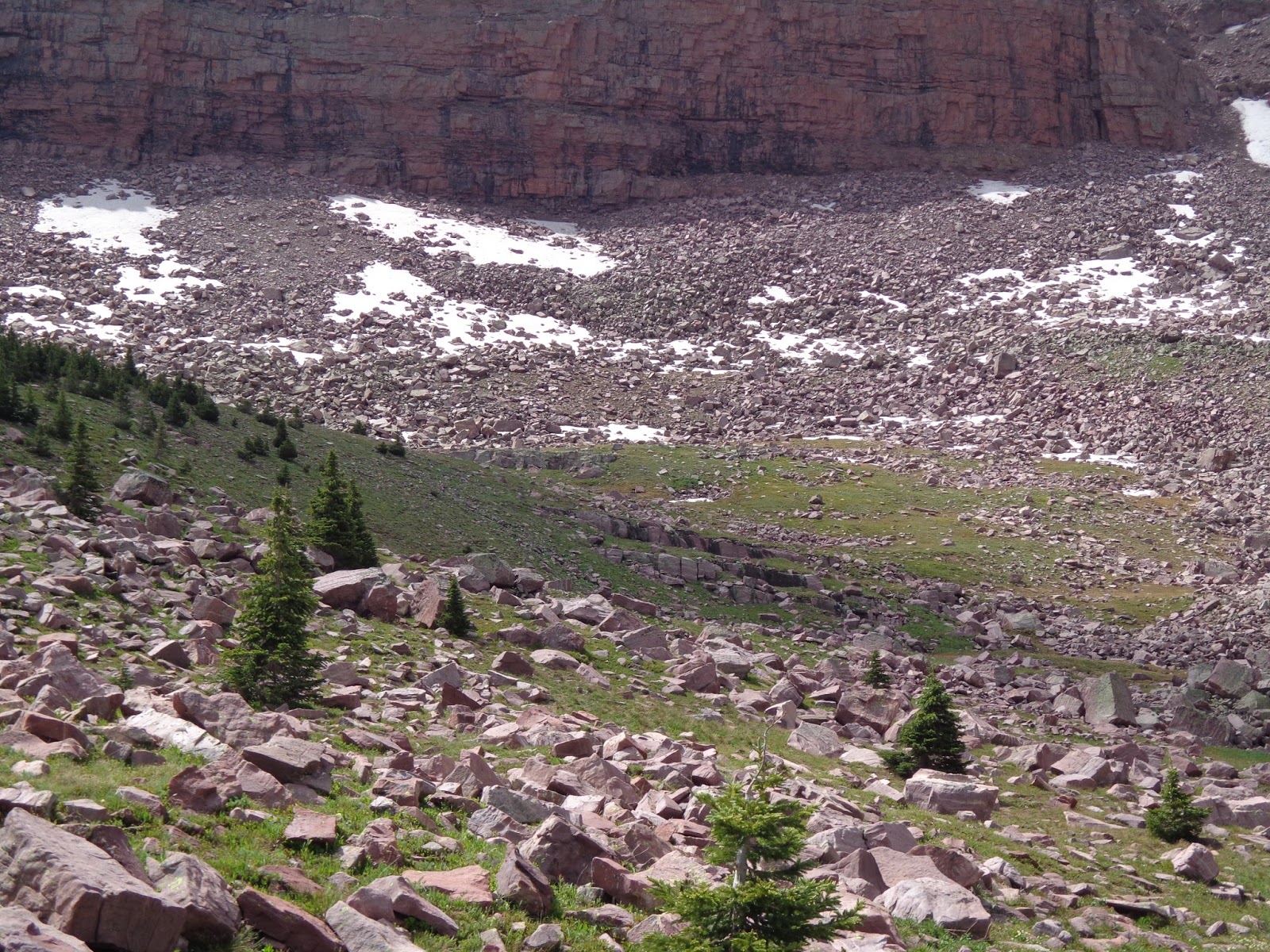
Finally, the red circle is the Wind River mountains, a wild alpine range that has at least a handful of major destination spots, especially for rock climbers (Titcomb Basin and Cirque of the Towers) as well as the highest peak in Wyoming (Gannet Peak, 13,804.)  There's also a beautifully done Wind Rivers High Route, which is mostly on trail, but not entirely.

The highest points—Gannet and Granite Peaks, although they draw lots of pilgrims, are kind of arbitrary, which is easy to see from this map.  Although Granite Peak is the highest peak in Montana, the border placement makes that kinda silly; it's a relatively modest peak for the GYE as a whole, which has a number of 13ers, including one in the Tetons, one in the Absarokas, and forty (yes, forty) in the Wind Rivers.

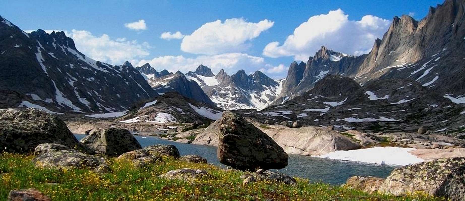
Wind Rivers from the Titcomb Basin area

Monday, November 23, 2015

Beartooth traverse options

For posterity (i.e., so I know where these links are later) here's a couple of routes for traversing the Beartooth range.

The second one is better explored in his book, which has a map.

http://backpackersresource.weebly.com/absoraka-beartooth-wilderness-traverse---cooke-city-mt.html

http://www.greatoutdoors.com/published/across-montanas-beartooths

http://backcountrypost.com/threads/a-very-late-beartooth-report.5305/

Probably the best way to combine the best of those is to do "The Beaten Path" as it's called (Cooke City to Rosebud via Fossil Lake and the plateau) but with an off-trail detour to hit up the hanging valleys of Martin Lake and Summit Lake (connected by a saddle traverse.)

Cliffs of Bergschrundt Lake

Wind River High Route

This is my own Caltopo representation of Adventure Alan's Wind River High Route.

The maps he includes look like screen grabs from Caltopo maps themselves, but I thought it useful to have my own version of the map I could play around with.


Wind River High Route from Don Wilson on Vimeo.

Gear (including new items)

Now that I'm nearly 6 months removed from my last backpacking trip (and at least six months from my next one, maybe more) it's time to review my gear.  I tried a few things, largely related to trying to get my son also outfitted without spending a ton of money, and some of them didn't work as well as I'd have liked, which means that they need to be re-thought.  Here's what I've got now:

Primary Gear

  • Cabela's XPG GORE-TEX Mid Hikers - I really liked these shoes.  They're good for at least several more years worth of hiking, at which point I'll want to replace them with something very similar.
  • Wenzel Escape 50L Pack - I really like this pack, too.  Last year, my son used it while I used one I got from a friend, who gave it to me for free after it didn't sell at his garage sale.  It ended up not working well; it was really uncomfortable and parts of it broke.  This was actually one of the main reasons I "gave up" early on my trip.  I really need another Escape 50.  Given that I've got most of the rest of what I need, even if I bring my son along again, I think I'll just buy a second Wenzel.  If I go solo, I'll just take the one I have.
  • Waistpack - I might want another one.  I have several very small ones, and one larger one that got DEET spilled all over it and kinda sorta dissolved parts of it.
Camping Gear
  • Outdoor Products All Purpose Tarp - I'm wondering how much I really need a tarp, honestly.  Camping here in Michigan in the rain, I think it might have actually contributed to more water issues than it prevented.  I'm tempted to toss the tarp and be done with it.
  • Ozark Trail egg-shell sleeping pad.  No issues.  I might by a second Thermarest from Wal-Mart.
  • Suisse Sport Adventurer Mummy Bag - I need to buy a second one.  I replaced the little light bag I had the year before, but then ended up using it again anyway so my son could have the warmer bag.  And then I was cold again.  Blegh.
  • Campmor 2 person dome tent - I'd love to get the Cabela's XPG Ultralight 2 person tent, but it costs $300.  I bought this for a tenth of the price, and it works fine.
  • Coleman inflatable pillow - I liked adding this to my line up.  It's pretty lightweight, but it made a big difference in comfort at night.
Clothing You Wear
  • Cabela's boonie hat - I might replace this with a regular baseball cap with a bandana clipped or sown in to cover my neck.  Maybe.  Or maybe not.
  • Fleece jacket - I've got several to choose from.  I'd like to add a lightweight puffer jacket to this, to keep me even warmer (especially at night) but I've been happy with the performance of my fleeces.
  • Long-sleeved nylon t-shirt - I've got several of these too.
  • Cabela's Lookout Peak Trail pants - although I've burned through one pair, I still have two more.  Not bad.  For the price, you can't beat 'em.
  • Midweight merino wool boot socks - again; I've got lots of pair.  I could pick up more if needed, since I use them day to day even when not hiking.
Clothing You Carry
  • Extra socks - see above
  • Manzella gloves - I might pass. I haven't really used them at all the last two years.
  • C9 packable rain jacket - I've also got a Frogg Toggs rain suit.  Either one would work fine.  You aren't like to wear either anyway, unless the rain sticks around for a while.
  • Beanie - the one I have is by Columbia, but any would do. 
  • Ozark Trail sandals - for stream crossings.  It's a pain to change your shoes out to cross rivers, but not as bad a pain as hiking for a long time with wet shoes.
  • Base Layers - I'll continue to use the ones I have; I bought them at Wal-Mart on an end of season clearance in January.
Cooking/Eating Gear
  • I need a new pocketknife.  After I got back from my trip the year before, I couldn't find the one I had brought anymore.  I don't know what happened to it, and I did actually use it the year before.  I don't really want to not have one.  But small, lightweight pocketknives cost less than $5 and are readily available all over the place.  No big deal.
  • Lightweight camp spoon and fork.
  • Elektek portable camp stove - a very small backpacking stove.  Works fine.
  • Stanley Camp cookset - fairly small, lightweight, and the stove packs inside.  Not room for the fuel canister, though.
Water/Drinking Equipment
  • Camelbak bladder
  • Power-ade bottle, rinsed out.
  • SteriPEN water purifier - no changes to any of this equipment.  I'd probably add a few portable drink mixes, though.  River water, even in the mountains, starts to taste blegh after a few days.
Personal/Miscellaneous
  • Camera - I really need my own.  Haven't decided yet which one to get, but for $100-$200 there's lots of choices.
  • Compass
  • First Aid Kit
  • Headlamp - I have a slightly heavier Coleman one, and a very small, lightweight one.  The very small one isn't really as bright as I like.  I might get a second bigger one if we go in groups of two again.
  • Insect treatment (permethrin) plus insect repellant - lots of mosquitos last year, but I didn't get a single bite.  I'm sold.
  • Map
  • Wipes.
Other than adding a second to some of the gear that I liked, but only have one of and therefore if I bring my son with me we can't both have one, the only thing that I'd really like to buy is a puffer jacket.  Here's a good deal on one:

Wednesday, November 18, 2015

Lake Blanche

Another highly desirable day hike to do while I'm in the Park City area is up to Lake Blanche (and Lakes Florence and Lillian while I'm at it, since all three are next to each other) in the Twin Peaks Wilderness, westward of Park City in the Wasatch Mountains.  This is the other major mountain range of Utah (and there are, of course, many smaller mountain ranges as well, but the Wasatch and the Uintas are the two really big ones.)  Because of its proximity to high population areas (the Salt Lake Valley in this case) it gets a fair bit of use, but if done on a weekday (other than July 4th) the crowds shouldn't be too bad.

It's over 2,600 of elevation gain, but only over about 3 miles.  This hike could be done, taken relatively easy, in two hours, plus some time to explore the lakes area, and then another hour or so to come back downhill to the car.  Even taking it easy and getting a relatively late start, it's not a long hike.  That estimate assumes walking pretty slow and taking lots of breaks to catch our breath.  The elevation gain is significant, but the distance is not.

Lake Blanche and the distinctive spur of Sundial behind it
Sundial from another angle, behind Lake Lillian
All three lakes from above

Friday, November 13, 2015

Ibantik Lake day hike

As a warm-up for the altitude before embarking on a bigger backpacking trip in the area; this is what I'd like to do.

There's a small bit of off-trail by crossing from the Notch Pass to the end of the Clyde Lake trail (or vice versa, depending on which leg of the loop you do first) and I'm not actually 100% sure that you can circumnavigate the entire lake without a lot of really ridiculous boulder hopping.  But it's a nice day hike.  Even taking a break at "The Notch" and again at Ibantik to explore, it's a relatively short trip, the elevation gain (and lost) isn't too bad (and I've heard it's also quite gradual, which is nice) and the views are spectacular.  For example:
Ibantik Lake
View from the Notch pass

Map of the hike.

Tuesday, November 10, 2015

One for the records... The Frog

https://picasaweb.google.com/115479031052354900696/TheFrog?gsessionid=pnwMx2izlkEX-7aDt1PbVQ

A dried up meander of the Green River near the northern edge of Canyonlands National Park.  A great October/November trip.

How to get there from Vernal.

Epic might-have-been

I'm disappointed that I second-guessed myself, quite honestly, and didn't stick to my original plan.  There are a few things that I've learned about myself and backpacking:

  • Going uphill is certainly hard.  I'm not well conditioned to do it, so I require lots of stopping to catch my breath.  Especially at altitude.  I need to get better at climbing and hiking uphill before I go on another major backpacking trip in the mountains.
  • My altitude acclimatization days didn't really work.  I spent the time, but still got hit with exhaustion and altitude sickness the first day that I actually backpacked anyway.  I'd have been better off starting right away and getting another day of backpacking done, rather than frittering the day away at high (but still lower) altitude seeing stuff that I'd already seen before.
  • You need to keep busy and keep moving.  When I end up with too much downtime, I just get bored and second guess how much I really want to be out in the wilderness.  Having places to go and things to see every day is important.
  • 10-12 miles in a day isn't terribly hard.  Sure, elevation gains can make a big difference in how far you walk, and the floor of the West Fork Blacks Fork canyon is relatively flat.  But that's relative.  From where I parked my car at the ford to Dead Horse Lake, we gained 1,551 feet.  That's not nothing, even if it lacked any big, steep sections where we switch-backed and gained a lot of elevation over a very short distance.  Although I should keep in mind that the elevation gain may have contributed to my rough first day; but my son had a rough day back out, which I did not.  So, while it contributes, it's probably not as big a deal as I think it is.  Especially if I get a little better conditioned to hiking uphill before I go next time.
  • I couldn't possibly have done this trip in less than 6 days.  7-8 is even better if I want to have a couple of days where I'm exploring from a temporary base camp without my pack.  I'm not sure that I really want to be out that long, or if I tend to feel like I'm "done" after about 4 days.  Then again, I'd probably do better if I slept better, and I've still struggled with gear just a bit.  I shouldn't be too eager to say that I don't want to be out longer when I've had a few minor gear struggles that in spite of being minor, certainly dimmed much of my enthusiasm for staying out.  I need, if I go with Alex or Logan again next time, to have another Escape 50 pack (the Escape 50 has performed well for two trips now; the other pack that I used last year did not) and another warmer sleeping bag (once again, my ability to use my little, compact sleeping bag did not end up being sufficient to keep me warm, making my nights pretty miserable.)  Solve those two problems, and I think I can spend a little longer in the field without getting tired of it.
So I'm tempted to resurrect the so called "Uintas 2015 Epic Loop" itinerary, with a few minor modifications.  Here's the original map again; I've cleaned up the lines just a bit.


  • Day 1: Rather than acclimate on the Mirror Lake Hwy, get to the trailhead as early as I can and hike nearly 10 miles to Lower Red Castle Lake.  Set up camp.  Take pictures and otherwise enjoy the area.  Maybe build a campfire, even.  Here's the directions to the trailhead.  Given that drive time, I'd need a very early start in the morning from my sister-in-law's place in Vernal; like 5 AM hit the road early. I do recognize that with a later start (because of traveling for a few hours before I can start hiking) and getting up and over Bald Mountain before heading into the Red Castle area is likely to make this a pretty killer first day.  But if I poop out early and break camp, I've got Day 2 (see below) to make up whatever I don't accomplish on Day 1. But ideally, I'd actually camp past Lower Red Castle Lake (see tent shaped marker.) Another option to make better time this day is to skip seeing family in Vernal until after the hike, and go directly to the trailhead.  There's camping there too. Distance: 9.67 miles.  Elevation Gain (not net): +2,860.
  • Day 2: Explore the Red Castle area a bit, including Red Castle Lake, Upper Red Castle Lake and cresting Wilson Pass to look over into Oweep Creek Basin.  Later in the itinerary, I'll hike that, but for now, it's just a photo op.  Relatively easy day, but with a campfire and some things to do and see, it shouldn't be an overly long and boring one. If I stopped a little early on Day 1, start the day off by moving the tent to the new location at the small unnamed lake near the tree line between Lower Red Castle Lake and Red Castle Lake.  Distance: 6.84 miles.  Elevation Gain: +1,732.
  • Day 3: 11½ mile hike to the Oweep Creek basin by cresting Smith's Fork Pass, Tungsten Pass and Porcupine Pass.  Although the mileage isn't a lot, cresting three passes means this will be a physically demanding day.  Camp in the shadow of Wilson Pass, not far from where I was overlooking the day before; although I will have gone a long way around to get there this time, seeing lots of scenery on the way. And if the weather looks bad, I'll have to add another mile or so to get to the tree line for the night.  Distance: 11.5 miles. Elevation Gain: +2,749.
  • Day 4: Cross the broad northern edge of the Yellowstone Basin and Lambert Meadows, leaving the trail near the end of the day to get to Crater Lake.  At nearly 13½ miles, this is a fairly long day, but without too much elevation change (about the same I actually experienced walking from the Ford for West Fork Blacks Fork to Dead Horse Lake last year, actually—just a pinch more.) Distance: 13.45 miles.  Elevation Gain: +1,759.
  • Day 5: This is a short day, although it means cresting Red Knob Pass and getting to Dead Horse Lake (deja vu).  Because the day is short, I can spend some time finding Lake Ejod and just generally exploring a few areas that I didn't see last time.  The original map route also shows a small detour to summit Red Knob (although I took that off for this version.)  I can decide whether or not to exercise that option depending on weather and time and how much I just feel like it or not. Distance: 6.17 miles.  Elevation Gain: +1,647.
  • Day 6: The orange line shows an option for crossing Dead Horse Pass and exploring a bit of the NE corner of Rock Creek Basin.  I could also, in theory, cross Allsop Pass to see Allsop Lake, although there's no trail there, and reports are that it's fairly steep and loose.  More likely, rather than taking a second day at Dead Horse Lake, I'd pack up and head back to the East Fork Blacks Fork valley, camping again off trail in that big eastern bight of Tokewanna at a little over 11,000 feet, as marked on the map (or maybe at the little unnamed lake just east of Wasatch Benchmark; only a mile or two short of the tent marker I put in.) Distance: 7.28 miles Elevation Gain: +2,367
  • Day 7: After a relatively short hike back to the car, we should be back in Vernal by mid-afternoon for showers and hamburgers at Freddy's, or Mexican food at Cafe Rio.  Sleeping in a bed and ready to roll the next day back towards home. Distance: 9.09 miles Elevation Gain: -2027.
Will I get tired of being out after 7 days?  I dunno yet.  I think I can do it.  Once I get started, I've only got a few opportunities to cut it shorter anyway: I could drop out Day 2 and just keep moving instead, but I'd have to make that call so early in the trip, that I probably wouldn't; I could cut out the Dead Horse Lake day and head straight from Crater Lake to Tokewanna that day instead.  If I did both, it'd be 5 days, but more likely I'd only do one of those if I were to do any.  I could also shorten the loop; cutting out the Day 3 mileage and doing Day 2 not as a backless exploration day, but actually taking Wilson Pass with my packs and setting up camp somewhere in Oweep or Yellowstone basin directly.  And if I really wanted to bail, I could take Squaw Pass from Yellowstone Basin to the Little East Fork trail, cutting out all of the Western part of the trip entirely.

In some ways, I'm not sure that I like having those options, though.  I'd rather feel committed to doing the full loop once I get started.

A bigger question: will Alex (assuming I bring him) or Logan get tired of the trip before it's over?  Well, I don't have to tell him that there are bail-out options, do I?  If I do, he may be begging for them for days, and who wants to listen to that?

A more salient question is when would I do this, given that I'm really pushing for a Colorado trip this coming summer rather than going back to the Uintas for a third year in a row.  I really wish I had time each year for 3-4 big backpacking trips, y'know?  Then I wouldn't feel like it's such a difficult question of prioritizing trips that I want to take.  There's a very remote chance that I could do this during my shut-down week, where I have to take vacation whether I want to or not, and then still have a chance to head out to Colorado in September.  But we'll see.  I think the chances of both of those happening in one year are remote.

Here's an image from a guy who explored much of this same territory this past August of the southern tip of the Mt. Lovenia ridge, which I'd pass on my way to Crater Lake.  Just as some inspiration.

Mt. Lovenia from Lambert Meadows

Thursday, August 20, 2015

Next year

Although my Uintas trip this summer ended up being significantly less ambitious than most of the plans I had been talking about here for a long time had laid out, I do still think that leaving the Uintas in 2016 is likely.  I like them, they're "my" range in many ways, but two trips into the Uintas (and another one as a teenager) has me thinking that it's time to see something else.

The best thing about the Uintas, of course, is that I can "home base" myself with my sister-in-law and her family in Vernal.  It's a couple of hours away from the Mirror Lake Hwy, since it's really on the wrong side of the range, but that makes it easier to get to her place after driving for two days, and easier to leave on my way back east to come home, so that's not necessarily bad news.  However, I'm just feeling like I've done enough Uintas for the time being, even with the areas that I still really want to see.  A Highline Trail thru-hike, or better yet, an alt-Highline Trail thru-hike is probably still in my future.
As a quick aside, by alt-Highline Trail, what I envision is starting the actual Highline at Hacking Lake, i.e. Mount Leidy, which is where the actual above treeline thrust of the Uintas starts.  I'd follow the Highline Trail west, making a brief detour to summit Kings Peak.  I'd then make another detour over Smiths Fork Pass and around Red Castle, before taking Wilson Pass above Upper Red Castle Lake to get back on the Highline Trail. 
I'd also detour slightly to stay a night at Crater Lake before crossing Red Knob Pass.  The section of the Highline Trail between Red Knob Pass and Deadhorse Pass is the only part of the trail where it is north of the main ridgeline of the Uintas, but I would take this opportunity to leave it for good, going instead over Allsop Pass above Dead Horse Lake, to see Allsop Lake.  Then it's basin hopping and lots of poor, unmarked trails (or no trails, in some cases—or going around maybe in some cases too)—from Allsop Lake, you go up between Yard and North Yard (or just north of North Yard is another option) into the Priord and Norice Lake basin.  Then over (or around) to Amethyst Lake and then to Middle Basin.  Then another hop over the Hayden-Agassiz ridge to the Mirror Lake Highway, and technically I may walk a little tiny bit on the far Western end of the Highline Trail. 
I thought about linking trails in the Western Uintas to complete what the Highline Trail does not; i.e., thru-hike the actual high points of the Uinta Mountains that are all up above treeline, ending at Yellow Pines Trail Head near Kamas.  Most likely, though, if I still even feel like it after doing that, I'd just take a day or two day hiking various locations in the Western Uintas; the Lofty Lakes loop, Notch Mountain, Ibantek Lake, etc.  Or maybe I actually even do that first as part of my altitude acclimatization activities.  That's what I meant to do last year, and I did, although I kept it more low-key than I would this time.
That said; that's some time in the future.  I'm going to leave the Uintas behind for 2016 and probably 2017 as well, at least although maybe even considerably longer, before seriously attempting that one.

Where would I like to hike next?  Well, starting in 2016 and for probably many years beyond, I'll have kids going to school in Rexburg, Idaho, which actually is extremely close to the northwestern Wyoming mountain majesties.  The Tetons, the Absarokas, the Wind Rivers, the Beartooth (actually north of the border in Montana mostly) are all right there, as well as other, lesser known ranges. (As another aside, it's great to have gotten married and started having kids early—in my early twenties.  I'm still in my early/mid 40s and next year I'll have two of my four kids in college with the Tetons on the horizon.  I intend to not even think about scaling back my hiking until I'm staring 70 in the face.  At least.)  Because I'll have an excuse to get up there anyway, these are destinations that make some sense, even if they're actually a bit farther to reach than the Uintas.

On the other hand, there are tons of places to see in Colorado that are a little bit less far, or at least no farther than the Uintas.  Although I'll have to "home base" in a hotel somewhere rather than with family (meaning two more nights of hotel and a hundred bucks at least more in the budget for the trip) that's not really a big deal, and the drive is still easy.  I'm actually favoring Colorado destinations for the next coupla years or so.  What specifically?

  • The Four Pass Loop in the Maroon Bells—Snowmass Wilderness, with a short detour to maybe summit Snowmass.  About 4-5 days tops.
  • Blue Lakes area in the Mount Sneffels Wilderness.  2-3 days.  I could add this to the Four Pass Loop.
  • I'd also really love to explore the West Elks Wilderness, which has among the lowest visitation in all of the Colorado Rockies.
  • In between Maroon Bells and the West Elks is the Raggeds Wilderness.
All of these are relatively close to each other, with Sneffels being the farthest from the other three (although not really by a ton) and located in  different range.  I'm kinda favoring doing the Four Pass Loop and Sneffels as one trip, and the Raggeds and West Elks as another trip another year.

There are, of course, many other beautiful locations in Colorado to explore, and I'd really love to do more than the small sampling I've done so far of the San Juans in particular.  But I've got to start somewhere.  Those are, for the time being, at the top of my list for trips for the next two years.

Elk Mountains

Mount Sneffels Wilderness

Wednesday, August 19, 2015

Digital manipulation

OK, I'm still not 100% convinced that this is the way to go, but I've done some more digital manipulation, and I like the results better than my first go-round with the process.


Monday, August 17, 2015

Burger secret sauce recipes

These aren't anything too dramatic, but they sound really good.  I'm archiving them here, and I fully intend to try them before the summer is over.

Chipotle Aioli
2 egg yolks
1 Tbsp lemon juice
1 tsp minced garlic
¼ tsp sugar
½ tsp salt
2 Tbsp chipotle peppers in adobo sauce
¾ cup olive oil

Place everything except oil in food processor, pulse until combined.  Slowly pour in oil and process for about a minute.  Refrigerate until used, or serve immediately.

A simpler "campfire sauce" can be made by combining equal parts mayonaise and BBQ sauce with a little bit of liquid smoke.

Playing around with image manipulation

Although I'm still very much a neophyte when it comes to doing this, I decided that many of my pictures came out a little bit flat, washed out, and colorless—at least compared to the original that I saw with my actual eyes.  I took a few of my hiking pictures from my most recent trip up WFBF valley to Dead Horse Lake—and a picture or two of some spots on the Mirror Lake Highway that we stopped as well—and increased the contrast a bit, the saturation, and the color vibrancy before applying a muted and modest vignette filter to the image.  The results are modest, and yet also striking.  Witness below, and then scroll down to my earlier pictures to compare to the original untouched, raw photographic data.

A few notes.  The first one needed it the most.  Due to weather conditions (very overcast, sprinkly, late afternoon, poor light) it was already faded and washed out looking more than most.  The pictures of the far walls of the cirque immediately after the hailstorm, with sun on the grass, trees and mountains, but dark clouds still lingering in the sky, are the most dramatic, and look the best, because the raw photographic data was the best.

A few of the bright sunlight pictures from the next day turned out a little odd—the saturation and contrast made the sky literally chance colors into a strange turquoise.  I probably need to do a bit more work to find out exactly what image enhancements actually give them the best look, rather than wallpapering the same adjustments to every picture.

I overdid the vignette filter on some of them.  I like it better when it's turned down in size and also grayed out just a bit.  Pure black at even a relatively low size is often too stark.


Wednesday, July 8, 2015

Uintas 2015, part 3

I took lots of pictures of Dead Horse lake and the outlet stream, but very few after that, as we were just doing the same route in reverse.  This is my final batch of Uintas pictures.

Walking up to Dead Horse Lake the next morning, after sleeping in.


We were actually quite close to the tree line at this point.

Alex, refusing to smile, on the trail to Dead Horse Lake.

It's hard to call this rushing outlet stream the West Fork Blacks Fork river when you're so close to the source, but I suppose that's what it is.

Right here is where the Highline Trail, a future goal of mine to hike, crosses the West Fork Blacks Fork trail and joins it on the way to the lake.  Apparently, it also goes up and over Dead Horse pass, but I lost track of the trail completely at the lake.

Walls of the cirque.

Alex trying to get out of the frame.  The lake was just over the small rise.


The elevation of Dead Horse Lake is 10,878, while the cliff buttresses to the left are over a thousand feet higher, and "Dead Horse Peak" to the center right is 12,642.  Again; the camera shrinks them and refuses to offer any indication of scale.

Allsop Pass, still capped with snow.


Although I've never heard confirmation that the big boulder pile at the base of the cliffs is a rock glacier, it must be, since the color of Dead Horse Lake is obviously influenced by rock flour.


Alex went a little around the corner to snap this picture of me on the shore.

Looking back at the outlet stream.

The colorful foreground peak of Beulah.

Close-up of the (presumed) rock glacier.

Standing right below the pass.


This close up actually gives a bit of scale lacking in the bigger pictures.

A beautiful place to sit and think.

Or to swat at mosquitoes.  Although we were well prepared and didn't get any bites, they were all over the place and were extremely aggravating whenever we stopped moving.

My thought was to circumnavigate the entire lake, but scrambling on these boulder fields didn't seem as much fun when it came right down to it as it did in theory before getting there.  Plus, the other party--a guy and his three teenaged kids--was just on the other side.  So we kept our distance and stayed on the pass side of the lake.  That's probably my biggest regret; that we didn't explore the other side just a bit and go find Lake Ejod while we were there.


The lake gradually turning into the river.  This is where it starts.

I turned around for one final farewell shot.

From the lake, Red Knob pass looks tremendous on the other side of the valley.  It's still odd to me that this peak isn't Red Knob, since it looks a lot more like a Red Knob than Red Knob itself does.


Stream crossing.  I walked it, but Alex didn't feel comfortable on his feet.


Another view of distant Red Knob pass.

Back up the valley, from whence we came the day before.


At the footbridge the next day on the way out.  I was having serious pack issues, which contributed to me cutting the planned hike a few days short.


One of the final pictures I took was of this deadfall blocking the trail.  There was actually a lot of it.  I also like this, because it clearly shows that the road used to go further in, before the National Forest decided to forget it, call part of the road a trail, and therefore not need to work as hard to keep it maintained anymore.