
Friday, July 10, 2015
Wednesday, July 8, 2015
Uintas 2015, part 3
I took lots of pictures of Dead Horse lake and the outlet stream, but very few after that, as we were just doing the same route in reverse. This is my final batch of Uintas pictures.


 |
| Walking up to Dead Horse Lake the next morning, after sleeping in. |

 |
| We were actually quite close to the tree line at this point. |
 |
| Alex, refusing to smile, on the trail to Dead Horse Lake. |
 |
| It's hard to call this rushing outlet stream the West Fork Blacks Fork river when you're so close to the source, but I suppose that's what it is. |
 |
| Right here is where the Highline Trail, a future goal of mine to hike, crosses the West Fork Blacks Fork trail and joins it on the way to the lake. Apparently, it also goes up and over Dead Horse pass, but I lost track of the trail completely at the lake. |
 |
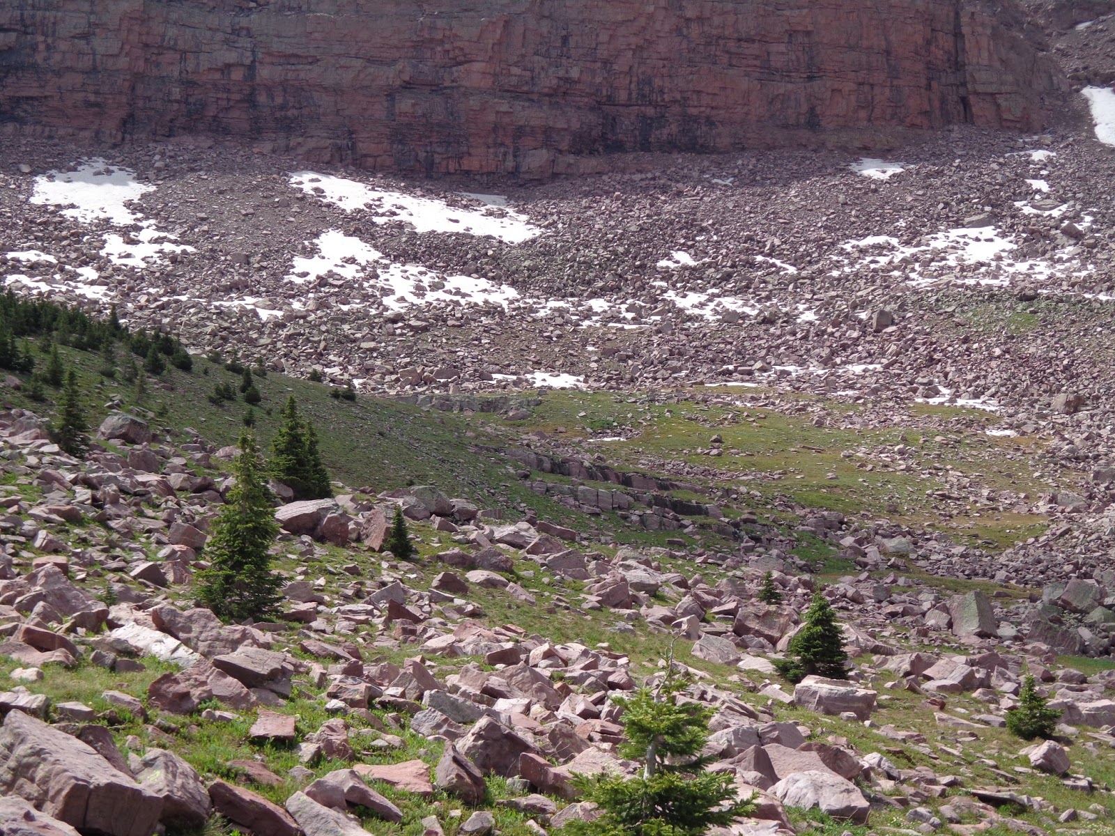
| Walls of the cirque. |
 |
| Alex trying to get out of the frame. The lake was just over the small rise. |


 |
| The elevation of Dead Horse Lake is 10,878, while the cliff buttresses to the left are over a thousand feet higher, and "Dead Horse Peak" to the center right is 12,642. Again; the camera shrinks them and refuses to offer any indication of scale. |
 |
| Allsop Pass, still capped with snow. |

 |
| Although I've never heard confirmation that the big boulder pile at the base of the cliffs is a rock glacier, it must be, since the color of Dead Horse Lake is obviously influenced by rock flour. |

 |
| Alex went a little around the corner to snap this picture of me on the shore. |
 |
| Looking back at the outlet stream. |
 |
| The colorful foreground peak of Beulah. |
 |
| Close-up of the (presumed) rock glacier. |
 |
| Standing right below the pass. |


 |
| This close up actually gives a bit of scale lacking in the bigger pictures. |
 |
| A beautiful place to sit and think. |
 |
| Or to swat at mosquitoes. Although we were well prepared and didn't get any bites, they were all over the place and were extremely aggravating whenever we stopped moving. |
 |
| My thought was to circumnavigate the entire lake, but scrambling on these boulder fields didn't seem as much fun when it came right down to it as it did in theory before getting there. Plus, the other party--a guy and his three teenaged kids--was just on the other side. So we kept our distance and stayed on the pass side of the lake. That's probably my biggest regret; that we didn't explore the other side just a bit and go find Lake Ejod while we were there. |


 |
| The lake gradually turning into the river. This is where it starts. |
 |
| I turned around for one final farewell shot. |
 |
| From the lake, Red Knob pass looks tremendous on the other side of the valley. It's still odd to me that this peak isn't Red Knob, since it looks a lot more like a Red Knob than Red Knob itself does. |

 |
| Stream crossing. I walked it, but Alex didn't feel comfortable on his feet. |


 |
| Another view of distant Red Knob pass. |
 |
| Back up the valley, from whence we came the day before. |


 |
| At the footbridge the next day on the way out. I was having serious pack issues, which contributed to me cutting the planned hike a few days short. |

 |
| One of the final pictures I took was of this deadfall blocking the trail. There was actually a lot of it. I also like this, because it clearly shows that the road used to go further in, before the National Forest decided to forget it, call part of the road a trail, and therefore not need to work as hard to keep it maintained anymore. |
Uintas 2015, part 2
Here's the West Fork Blacks Fork leg of the trip, or at least the pictures thereof. We got a little bit later start than I would have liked due to a couple of complications first thing in the morning, and I didn't drive all the way to the trailhead, because I wasn't comfortable taking my car through the ford. This added about a mile and a half or so to the route, and as it happened, we wrapped up our first day about a mile and a half short of of our destination at Dead Horse Lake. By then, of course, we decided not to move the camp, but just go up to the lake and explore it as it was.
We spent a very lazy next day; I had thought it would be fun to climb up the pass a bit and go look for Ejod Lake, but I allowed myself to get talked out of it by my son, who had convinced himself that we were about to get stormed on any second now while we were at Dead Horse. So, we headed back to camp and lazed around for several hours instead. The good news is, that gives me an excuse to head back some time!


We spent a very lazy next day; I had thought it would be fun to climb up the pass a bit and go look for Ejod Lake, but I allowed myself to get talked out of it by my son, who had convinced himself that we were about to get stormed on any second now while we were at Dead Horse. So, we headed back to camp and lazed around for several hours instead. The good news is, that gives me an excuse to head back some time!
 |
| Approaching the Woodpile. |
 |
| Due to complications, we got a later start than I would have liked, but Alex was still jacketed up anyway. |
 |
| The dead trees around the Woodpile were ominous. The name predates the big pine beetle bloom of about ten years or so ago, doesn't it? |
 |
| I decided that I wasn't happy driving my car through the ford; I just have a small passenger car, after all. This was as far as I got before we unloaded and started walking. |
 |
| The first stream crossing. |
 |
| Here the trail looks pretty good, but it often got lost in extremely boggy meadows. We were just after snowmelt, so the trail conditions weren't the best. Tons of mud, and tons of mosquitos. And even in the best of conditions, the trail is often lost in the meadows, it appears. |
 |
| Again with the radioactive shirt, getting ready for another stream crossing. |
 |
| The trail here stays a little higher than the meadow levels, just right near the trees, and occasionally crosses to the other side of the valley. For most of the first third of the trail, you're in the forest, for most of the second third, you're on the west side with great views of the Tokewanna ridge, and for most of the third third, you're on the east side checking out the rugged cliffs of Beulah. |
 |
| Storms gathering over our destination. |
 |
| The camera really shrinks this; Tokewanna completely filled our field of vision when looking at it from here. |
 |
| About to make the third stream crossing and have views of Beulah, starting with these. |
 |
| The meadow was extremely boggy here, and we ended up walking along the fence as much as we can so we didn't lose our shoes in the sucking mud, but it was nice to have this rough footbridge to actually cross the river this time. |
 |
| Ruins of an old cabin, presumably that of a tie-hacker from a hundred years or so ago. |
 |
| Alex decided that since it was me instead of his mother, he didn't have to smile and pose for very many pictures, but here's a nice one. |
 |
| Getting closer to our destination, the weather took a turn for the worse. |

 |
| We got to within no more than a hundred yards... maybe less... of these two young bull moose. |

 |
| Chased into the trees to wait out a quick hailstorm cloudburst. |
 |
| After the hailstorm, sun hit the mountains of our destination, but my momentum had been seriously shot. I was having technical difficulties with my backpack, and wasn't as acclimated to the altitude as I'd hoped. As it happened, we didn't quite make it to the lake after all before it started getting darker than we wanted it to. |
 |
| The cirque near Dead Horse lake was one of the most beautiful places I've ever been. |
 |
| Clouds and sun on Red Knob. |
 |
| Looking backwards a bit; with Alex not quite getting out of frame fast enough. |
 |
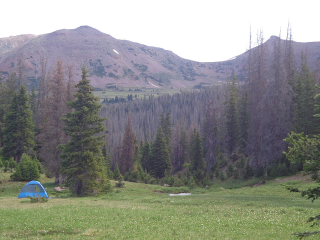
| Beulah as the sun was setting. We decided to set up camp here at a nice smooth spot next to the outlet stream, which eventually grows to be worthy of being called the West Fork Blacks Fork river, a little bit downstream. |
 |
| Out campsite. My shoes and socks are drying in the sun. |


Subscribe to:
Comments (Atom)